1920s Maps of Knollwood Country Club Estates, Los Angeles
Explore 7 historic maps of Knollwood Country Club Estates from the 1920s. These maps offer a rare glimpse into what life looked like during the 1920s — showing old roads, neighborhoods, homes, and landmarks that have changed or disappeared over time.
Whether you're researching your family's past, planning a metal detecting trip, or studying how Knollwood Country Club Estates's landscape evolved across the 1920s, these high-resolution maps are a powerful tool for exploring the history of this region.
- Focus on a specific era: All maps on this page are from the 1920s, giving you a focused view of this time period.
- See what’s changed: Compare century-old streets, trails, and buildings to today's modern landscape using overlays and satellite layers.
- Research with precision: Use these maps for genealogy, historical research, land use analysis, or educational projects.
- View, download, or print: Maps are fully viewable online in high resolution, and can be downloaded or printed for your own records.
Start exploring Knollwood Country Club Estates's history through authentic maps from the 1920s. This is your window into the past.
Knollwood Country Club Estates, Los Angeles maps
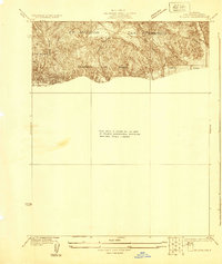
(7)- 1925 Map of Sylmar
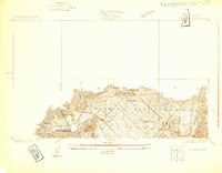 1925 Sylmar1925 Print · USGSThe northern San Fernando Valley is captured here in the mid-twenties, showing a landscape of emerging infrastructure and public institutions. Trace early water and power networks at the Upper San Fernando Reservoir or locate local landmarks like the El Retiro School for Girls and Sylmar.
 - 1927 Map of Pacoima
 1927 Pacoima1927 Print · USGSThe northern San Fernando Valley is seen here during the mid-1920s as early citrus groves and ranch lands began giving way to a modern street grid. Researchers can trace the layout of early communities like Mission Acres and Pacoima or locate the historic grounds of the San Fernando Mission.4 unique versions available
 - 1928 Map of Zelzah
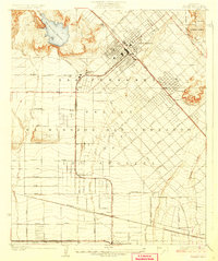
 1928 Zelzah1928 Print · USGSThe San Fernando Valley was transitioning from vast ranchos to specialized farming and suburban tracts in the late 1920s. Trace the early rail-connected settlements of Zelzah and Owensmouth alongside the unique Weeks Poultry Colony.
 - 1928 Map of Sylmar
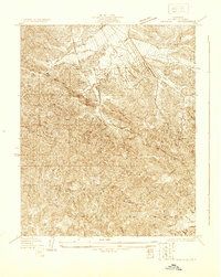
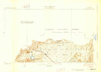 1928 Sylmar1928 Print · USGSThe northern reaches of Los Angeles are seen here in the late 1920s, still bounded by the old lines of the Ex Mission San Fernando. Genealogists and historians can trace institutional sites like the Olive View Sanatorium and the San Fernando Cemetery along the Southern Pacific rail line.
 - 1929 Map of Sylmar
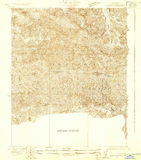 1929 Sylmar1929 Print · USGSThe foothills of the San Gabriel Mountains are captured here in the late 1920s, showing a landscape defined by forest terrain and early public health infrastructure. Researchers can locate specialized sites like the Olive View Sanatorium and trace the paths of the early Aqueduct and Transmission Line.
 - 1929 Map of Zelzah
 1929 Zelzah1929 Print · USGSThe northern San Fernando Valley is shown here just before the era of major suburban density, when deep canyons still dominated the landscape. Genealogists and hikers can trace the early layout of Twin Lakes Park and the original path of Rinaldi Street.
 - 1929 Map of Newhall
 1929 Newhall1929 Print · USGSNorthern Los Angeles during the late 1920s shows a landscape of deep canyons and the historic Ex Mission San Fernando boundary. Genealogists and hikers can trace old routes through San Fernando Pass and along Placerita Creek.
End of results
Showing maps 1-7 of 7
Frequently asked questions
- What are the different types of historical maps available for Knollwood Country Club Estates?
- What is the oldest map of Knollwood Country Club Estates?
- Where can I purchase historical maps of Knollwood Country Club Estates for my home or office?
- Where can I download high-res historical maps of Knollwood Country Club Estates?
- Are there historical topographic maps available for Knollwood Country Club Estates?
- Is there historical aerial imagery available for Knollwood Country Club Estates?
- Where are historical maps of Knollwood Country Club Estates sourced from?