1960s Maps of Redondo Beach, California
Explore 5 historic maps of Redondo Beach from the 1960s. These maps offer a rare glimpse into what life looked like during the 1960s — showing old roads, neighborhoods, homes, and landmarks that have changed or disappeared over time.
Whether you're researching your family's past, planning a metal detecting trip, or studying how Redondo Beach's landscape evolved across the 1960s, these high-resolution maps are a powerful tool for exploring the history of this region.
- Focus on a specific era: All maps on this page are from the 1960s, giving you a focused view of this time period.
- See what’s changed: Compare century-old streets, trails, and buildings to today's modern landscape using overlays and satellite layers.
- Research with precision: Use these maps for genealogy, historical research, land use analysis, or educational projects.
- View, download, or print: Maps are fully viewable online in high resolution, and can be downloaded or printed for your own records.
Start exploring Redondo Beach's history through authentic maps from the 1960s. This is your window into the past.
Redondo Beach, CA maps
(5)- 1960 Map of Long Beach
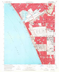
 1960 Long Beach1960 Print · USGSCoastal California at the height of post-war expansion reveals a dense network of suburban growth and maritime industry. Trace the development of the South Bay and inland neighborhoods like Lakewood Village, or explore the topography of Santa Catalina Island and Los Angeles Harbor.2 unique versions available
 - 1963 Map of Redondo Beach, 1965 Print
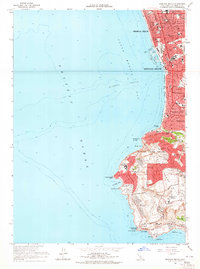 1963 Redondo Beach1965 Print · USGSThe South Bay coast and Palos Verdes Peninsula were undergoing significant suburbanization in the early sixties. Researchers can trace the era's infrastructure from the King Harbor waterfront to local landmarks like Marineland and the Atchison Topeka and Santa Fe rail line.4 unique versions available
 - 1964 Map of Inglewood, 1965 Print
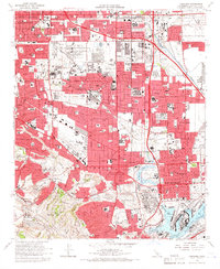
 1964 Inglewood1965 Print · USGSSouthwestern Los Angeles County undergoes a mid-century suburban boom in this detailed record of the South Bay and Inglewood area. Genealogists and historians can trace neighborhood growth near Inglewood Park Cemetery, Lennox High Sch, and the local Oil Field operations.4 unique versions available
 - 1964 Map of Venice, 1965 Print
 1964 Venice1965 Print · USGSThe Los Angeles coastline undergoes a massive mid-century transformation as Marina del Rey and Los Angeles International Airport expand. Researchers can trace the growth of Westchester or find coastal landmarks like the Ocean Park Pier and Dockweiler Beach State Park.4 unique versions available
 - 1964 Map of Torrance, 1966 Print
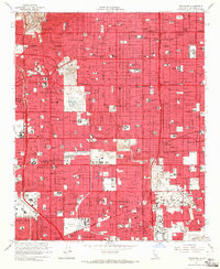
 1964 Torrance1966 Print · USGSMid-century Los Angeles County is captured here during a period of massive industrial and suburban growth. Genealogists and historians can locate dozens of neighborhood landmarks, from the Banning Drum Barracks to local schools like Bishop Montgomery High Sch and Casimir Sch.3 unique versions available
End of results
Showing maps 1-5 of 5
Top cities near Redondo Beach
- Los Angeles historical maps
- Long Beach historical maps
- Torrance historical maps
- Inglewood historical maps
- Compton historical maps
- South Gate historical maps
See more
Top neighborhoods of Redondo Beach
Frequently asked questions
- What are the different types of historical maps available for Redondo Beach?
- What is the oldest map of Redondo Beach?
- Where can I purchase historical maps of Redondo Beach for my home or office?
- Where can I download high-res historical maps of Redondo Beach?
- Are there historical topographic maps available for Redondo Beach?
- Is there historical aerial imagery available for Redondo Beach?
- Where are historical maps of Redondo Beach sourced from?