1990s Maps of Hollywood Riviera, Torrance
Explore 1 historic maps of Hollywood Riviera from the 1990s. These maps offer a rare glimpse into what life looked like during the 1990s — showing old roads, neighborhoods, homes, and landmarks that have changed or disappeared over time.
Whether you're researching your family's past, planning a metal detecting trip, or studying how Hollywood Riviera's landscape evolved across the 1990s, these high-resolution maps are a powerful tool for exploring the history of this region.
- Focus on a specific era: All maps on this page are from the 1990s, giving you a focused view of this time period.
- See what’s changed: Compare century-old streets, trails, and buildings to today's modern landscape using overlays and satellite layers.
- Research with precision: Use these maps for genealogy, historical research, land use analysis, or educational projects.
- View, download, or print: Maps are fully viewable online in high resolution, and can be downloaded or printed for your own records.
Start exploring Hollywood Riviera's history through authentic maps from the 1990s. This is your window into the past.
Hollywood Riviera, Torrance maps
(1)- 1996 Map of Redondo Beach, 2000 Print
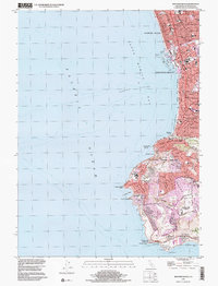 1996 Redondo Beach2000 Print · USGSThe South Bay and Palos Verdes Peninsula are shown here in the mid-nineties, capturing the area's established suburban character and dramatic coastline. Researchers can trace local development through landmarks like Marineland, Mira Costa High School, and the Point Vicente lighthouse.
End of results
Showing maps 1-1 of 1
Top cities near Hollywood Riviera
- Los Angeles historical maps
- Long Beach historical maps
- Torrance historical maps
- Inglewood historical maps
- Downey historical maps
- Compton historical maps
See more
Frequently asked questions
- What are the different types of historical maps available for Hollywood Riviera?
- What is the oldest map of Hollywood Riviera?
- Where can I purchase historical maps of Hollywood Riviera for my home or office?
- Where can I download high-res historical maps of Hollywood Riviera?
- Are there historical topographic maps available for Hollywood Riviera?
- Is there historical aerial imagery available for Hollywood Riviera?
- Where are historical maps of Hollywood Riviera sourced from?