1950s Maps of Unincorporated Santa Monica Mountains, California
Explore 13 historic maps of Unincorporated Santa Monica Mountains from the 1950s. These maps offer a rare glimpse into what life looked like during the 1950s — showing old roads, neighborhoods, homes, and landmarks that have changed or disappeared over time.
Whether you're researching your family's past, planning a metal detecting trip, or studying how Unincorporated Santa Monica Mountains's landscape evolved across the 1950s, these high-resolution maps are a powerful tool for exploring the history of this region.
- Focus on a specific era: All maps on this page are from the 1950s, giving you a focused view of this time period.
- See what’s changed: Compare century-old streets, trails, and buildings to today's modern landscape using overlays and satellite layers.
- Research with precision: Use these maps for genealogy, historical research, land use analysis, or educational projects.
- View, download, or print: Maps are fully viewable online in high resolution, and can be downloaded or printed for your own records.
Start exploring Unincorporated Santa Monica Mountains's history through authentic maps from the 1950s. This is your window into the past.
Unincorporated Santa Monica Mountains, CA maps
(13)- 1950 Map of Triunfo Pass
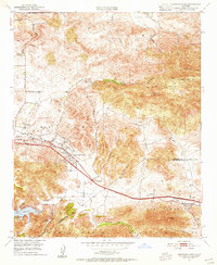
 1950 Triunfo Pass1950 Print · USGSThe coastal Santa Monica Mountains come into focus just after the war as new highways begin to carve through the canyons. Genealogists and hikers can trace the original locations of Yerba Buena Sch, Solromar, and the Triunfo Lookout.2 unique versions available
 - 1950 Map of Thousand Oaks, 1955 Print
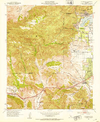
 1950 Thousand Oaks1955 Print · USGSThousand Oaks and the surrounding ranch lands are shown here in the early fifties, just as the regional highway network began to modernize. Researchers can locate early community hubs like Triunfo Corner, Greenwich Village, and the Conejo Sch.5 unique versions available
 - 1950 Map of Malibu Beach, 1955 Print
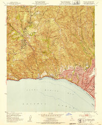
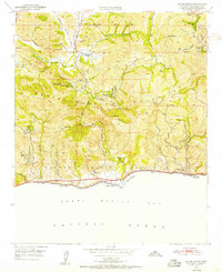 1950 Malibu Beach1955 Print · USGSCoastal Los Angeles County at mid-century reveals a landscape of private ranches and mountain retreats tucked into the canyons. Researchers can trace early property lines and landmarks like Century Ranch, the Salvation Army Camp, and Las Flores.7 unique versions available
 - 1950 Map of Point Dume, 1956 Print
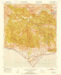
 1950 Point Dume1956 Print · USGSThe coastal canyons and peaks of western Los Angeles County appear here in the early fifties, before the surge of modern residential expansion. Researchers can trace early ranch sites like Kincaid Ranch, visit Seminole Hot Springs, or locate the Castro Pk Lookout.6 unique versions available
 - 1951 Map of Malibu Beach
 1951 Malibu Beach1951 Print · USGSThe Malibu coast and interior canyons come alive in the early 1950s, showing a landscape of remote ranches and seaside retreats. Researchers can trace early mountain landmarks like Century Ranch, find the Las Virgenes Sch, or locate coastal features like Serra Retreat.
 - 1951 Map of Point Dume
 1951 Point Dume1951 Print · USGSThe coastal mountains of Malibu and the Santa Monica range appear here in the early fifties, before the arrival of modern suburban sprawl. Researchers can trace historic landmarks like Seminole Hot Springs, the Kincaid Ranch, and the early layout of Malibu Riviera.
 - 1952 Map of Thousand Oaks
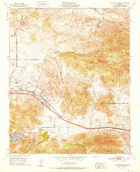 1952 Thousand Oaks1952 Print · USGSThousand Oaks and the Conejo Valley are captured in the early fifties, just as this ranching region began to modernize. Researchers can locate the original Conejo School, the Conejo Valley Airport, and old landmarks like Triunfo Corner and the Olson Cemetery.
 - 1952 Map of Calabasas, 1953 Print
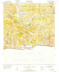
 1952 Calabasas1953 Print · USGSThe western San Fernando Valley meets the Simi Hills in the early fifties, showing a landscape of foothill ranching and early canyon communities. Genealogists can locate family landmarks like Chatsworth Lake Manor, the L A Pet Cemetery, and Las Virgenes School.9 unique versions available
 - 1952 Map of Topanga, 1953 Print
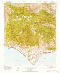
 1952 Topanga1953 Print · USGSCoastal Los Angeles and the adjacent canyon country appear in the early fifties as the region began its mid-century transformation. Researchers can trace the development of Pacific Palisades, the grounds of Will Rogers State Park, and rural landmarks like Trippet Ranch.8 unique versions available
 - 1955 Map of Los Angeles
 1955 Los Angeles1955 Print · USGSThe mid-century transformation of Southern California comes into focus as the urban sprawl of Los Angeles meets the wilderness of the Santa Monica Mountains. Researchers can trace the development of post-war suburbs alongside historic landmarks like the Santa Barbara Lighthouse and early industrial sites such as the Good Luck Mine.
 - 1957 Map of Long Beach
 1957 Long Beach1957 Print · USGSThe Los Angeles coast and the Channel Islands appear here during the mid-fifties era of rapid suburbanization and naval expansion. Genealogists and researchers can locate early industrial neighborhoods like South Gate and trace military boundaries at Ft MacArthur Upper Reservation or the remote San Nicolas Island.4 unique versions available
 - 1958 Map of Long Beach
 1958 Long Beach1958 Print · USGSCoastal Southern California is shown during a mid-century period of intense suburbanization and military readiness. Genealogists and historians can trace the growth of Long Beach, identify early neighborhoods in Lakewood Village, or locate the bounds of Ft MacArthur Lower Reservation.
 - 1959 Map of Los Angeles
 1959 Los Angeles1959 Print · USGSCoastal California and the high desert met in a period of booming growth after the war. Researchers can trace early aviation and military history at the Point Mugu Air Missile Test Ctr or locate desert mining sites like the Double Eagle Mine.3 unique versions available
End of results
Showing maps 1-13 of 13
Top cities near Unincorporated Santa Monica Mountains
- Los Angeles historical maps
- Thousand Oaks historical maps
- Simi Valley historical maps
- Santa Monica historical maps
- Camarillo historical maps
- Moorpark historical maps
See more
Top neighborhoods of Unincorporated Santa Monica Mountains
- Monte Nido historical maps
- Crater Camp historical maps
- El Nido historical maps
- Seminole Hot Springs historical maps
- Cornell historical maps
- Malibu Bowl historical maps
See more
Frequently asked questions
- What are the different types of historical maps available for Unincorporated Santa Monica Mountains?
- What is the oldest map of Unincorporated Santa Monica Mountains?
- Where can I purchase historical maps of Unincorporated Santa Monica Mountains for my home or office?
- Where can I download high-res historical maps of Unincorporated Santa Monica Mountains?
- Are there historical topographic maps available for Unincorporated Santa Monica Mountains?
- Is there historical aerial imagery available for Unincorporated Santa Monica Mountains?
- Where are historical maps of Unincorporated Santa Monica Mountains sourced from?