1930s Maps of Monte Nido, Unincorporated Santa Monica Mountains
Explore 1 historic maps of Monte Nido from the 1930s. These maps offer a rare glimpse into what life looked like during the 1930s — showing old roads, neighborhoods, homes, and landmarks that have changed or disappeared over time.
Whether you're researching your family's past, planning a metal detecting trip, or studying how Monte Nido's landscape evolved across the 1930s, these high-resolution maps are a powerful tool for exploring the history of this region.
- Focus on a specific era: All maps on this page are from the 1930s, giving you a focused view of this time period.
- See what’s changed: Compare century-old streets, trails, and buildings to today's modern landscape using overlays and satellite layers.
- Research with precision: Use these maps for genealogy, historical research, land use analysis, or educational projects.
- View, download, or print: Maps are fully viewable online in high resolution, and can be downloaded or printed for your own records.
Start exploring Monte Nido's history through authentic maps from the 1930s. This is your window into the past.
Monte Nido, Unincorporated Santa Monica Mountains maps
(1)- 1932 Map of Las Flores
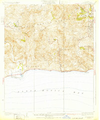 1932 Las Flores1932 Print · USGSCoastal Los Angeles County appears at the dawn of the 1930s as a series of isolated canyon outposts and emerging beach colonies. Historians and researchers can trace the early layouts of Malibu Beach, Stunts Ranch, and Topanga while exploring the original path of the State Highway.2 unique versions available
End of results
Showing maps 1-1 of 1
Top cities near Monte Nido
- Los Angeles historical maps
- Torrance historical maps
- Thousand Oaks historical maps
- Simi Valley historical maps
- Santa Monica historical maps
- Redondo Beach historical maps
See more
Frequently asked questions
- What are the different types of historical maps available for Monte Nido?
- What is the oldest map of Monte Nido?
- Where can I purchase historical maps of Monte Nido for my home or office?
- Where can I download high-res historical maps of Monte Nido?
- Are there historical topographic maps available for Monte Nido?
- Is there historical aerial imagery available for Monte Nido?
- Where are historical maps of Monte Nido sourced from?