Old Maps of Whittier, California for Academic Research
Study the evolution of Whittier with 64 high-resolution historic maps. Whether you're teaching, researching, or modeling changes in land use, these maps provide essential visual documentation of urban, environmental, and geographic change.
- Analyze long-term change: Track patterns in development, transportation, and natural features.
- Ideal for environmental or urban studies: Support academic projects with primary historical map data.
- Use in the classroom or lab: Educators and researchers rely on these maps to bring historical context to life.
These maps are a powerful tool for teaching, research, and visualizing how Whittier has changed over the decades.
Whittier, CA maps
(64)- 1894 Map of Los Angeles
 1894 Los Angeles1894 Print · USGSLos Angeles was a growing rail hub at the end of the nineteenth century, balancing its agricultural heritage with new mountain resorts. Researchers can trace early neighborhoods like Boyle Heights, find the National Soldiers Home, or follow the Mt. Lowe Hotel incline.
 - 1896 Map of Pasadena
 1896 Pasadena1896 Print · USGSGreater Los Angeles was a network of rail-connected resort towns and historic missions in the late nineteenth century. You can trace early transit lines to the Raymond Hotel, locate the original Mission site, and find vanished stops like Las Casetas Sta.2 unique versions available
 - 1896 Map of Anaheim
 1896 Anaheim1896 Print · USGSThe Orange County basin appears here in the mid-1890s, when iron rails first connected the young citrus towns to the wider world. Genealogists and researchers can trace the early grids of Anaheim, Fullerton, and Orange alongside now-obscure rail stops like Almond and Marlboro.
 - 1896 Map of Downey
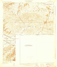
 1896 Downey1896 Print · USGSThe Los Angeles Basin was a landscape of vast ranchos and emerging rail towns in the 1890s. Genealogists and historians can trace the early footprints of Downey and Whittier, alongside unique landmarks like the Poor Farm Sta. and Fulton Wells.
 - 1898 Map of Anaheim, 1899 Print
 1898 Anaheim1899 Print · USGSNorthern Orange County is captured here at the height of its citrus and rail era. Genealogists and local historians can trace the early footprints of Anaheim, Fullerton, and Orange, alongside smaller vanished stops like McPherson and Almond.
 - 1899 Map of Downey
 1899 Downey1899 Print · USGSCoastal Los Angeles County at the close of the nineteenth century reveals a landscape of massive ranchos being carved into early townships. Genealogists can trace family roots through historic rail stops like Obed Bell Sta. and vanished settlements like Spanishtown or Nadeau Park.
 - 1900 Map of Pasadena
 1900 Pasadena1900 Print · USGSThe San Gabriel Valley is captured here at a pivotal moment of expansion just as the rail networks reached the foothills. Researchers can trace the layout of early Pasadena and Monrovia, locate the Echo Mountain Mt. Lowe Hotel, or find the historic Mission and Raymond Hotel.10 unique versions available
 - 1900 Map of Los Angeles
 1900 Los Angeles1900 Print · USGSGreater Los Angeles was a mosaic of expansive ranchos and emerging rail towns at the turn of the century. You can trace the early footprints of Hollywood, locate the historic Soldiers Home, and follow the mountain rails to the Echo Mountain Mt. Lowe Hotel.4 unique versions available
 - 1901 Map of Southern California Sheet No. 1
 1901 Southern California Sheet No. 11901 Print · USGSGreater Los Angeles at the dawn of the twentieth century is a landscape of growing citrus towns and a burgeoning rail network. Genealogists and historians can trace the early gridded streets of Hollywood and Pasadena or locate landmarks like Bear Lake and the Cahuilla Indian Reservation.6 unique versions available
 - 1901 Map of Anaheim
 1901 Anaheim1901 Print · USGSOrange County's citrus and rail heartland is meticulously detailed at the start of the century, showing the early layouts of Anaheim and Fullerton. Genealogists can trace early homesteads and rail stops like Loara, Miraflores, and Olinda.6 unique versions available
 - 1902 Map of Downey
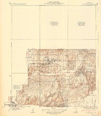
 1902 Downey1902 Print · USGSThe Los Angeles coastal plain at the turn of the century shows a network of early citrus towns and Spanish rancho boundaries. Trace the development of the river system and rail stops like Poor Farm Sta., Fulton Wells, and the growing community of Whittier.9 unique versions available
 - 1902 Map of Corona
 1902 Corona1902 Print · USGSThe Orange County and Riverside borderlands at the start of the 1900s show an era of rapid rail expansion and water engineering. Researchers can trace the early footprints of Anaheim and Orange or find vanished industry at the Santiago Coal Mine.7 unique versions available
 - 1904 Map of Southern California Sheet No. 1, 1905 Print
 1904 Southern California Sheet No. 11905 Print · USGSSouthern California at the dawn of the twentieth century shows a landscape of citrus groves and coastal towns connected by rail. Genealogists and historians can trace early settlements like San Juan Capistrano, find remote sites like the Rose Mine, and study the original water systems of the Santa Ana River.2 unique versions available
 - 1923 Map of El Monte
 1923 El Monte1923 Print · USGSThe San Gabriel Valley was a thriving agricultural and rail corridor in the years following the Great War. You can trace early township boundaries and find the sites of rural schools and industry, from the O'Donnel Oil Refinery to the Temple School.
 - 1923 Map of Whittier
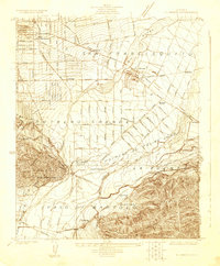
 1923 Whittier1923 Print · USGSSoutheast Los Angeles County is captured here in the early twenties during a period of rapid agricultural and industrial expansion. Genealogists and local historians can trace the foundations of Santa Fe Springs and Colima, or locate family sites near Little Lake School and Mt Olive Cem.
 - 1925 Map of Whittier
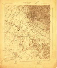
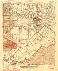
 1925 Whittier1925 Print · USGSLos Angeles County during the 1920s petroleum boom reveals a landscape of expanding towns and industrial grit. Researchers can trace the early footprints of Santa Fe Springs, the sprawling Oil Wells, and local institutions like the Norwalk State Hospital.2 unique versions available
 - 1926 Map of El Monte
 1926 El Monte1926 Print · USGSThe San Gabriel Valley in the mid-twenties shows a landscape of historic ranchos transitioning into suburban clusters along the rail lines. Genealogists and researchers can trace early homesteads and schools like Temple School or the industrial footprint of the O'Donnel Oil Refinery.2 unique versions available
 - 1927 Map of La Habra
 1927 La Habra1927 Print · USGSSouthern California ranching meets the oil boom in the late twenties as the petroleum industry reshapes the landscape. Genealogists can locate family holdings like Grazide Ranch or trace local education at Lowell Joint School and Rowland School.2 unique versions available
 - 1935 Map of Coyote Hills
 1935 Coyote Hills1935 Print · USGSThe Orange and Los Angeles county line comes alive in the 1930s as citrus ranches and oil infrastructure began to reshape the Coyote Hills. Researchers can trace the early footprints of Brea, the expansive Bastonchury Ranch, and the Union Oil Tank Farm.2 unique versions available
 - 1942 Map of Downey
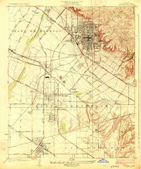
 1942 Downey1942 Print · USGSThe Los Angeles Basin and North Orange County appear here during the wartime boom, showcasing a landscape transitioning from ranchos to suburbs. Trace the historic Pacific Electric rail lines, the oil fields of Santa Fe Springs, and early settlements like Hynes and Studebaker.
 - 1942 Map of Anaheim
 1942 Anaheim1942 Print · USGSOrange County's agricultural heart is captured mid-century during a period of rapid wartime development. Genealogists can locate family landmarks like Diamond Bar Ranch, local schools such as Alamitos Sch, and communities like Garden Grove or Stanton.2 unique versions available
 - 1943 Map of San Pedro
 1943 San Pedro1943 Print · USGSThe South Bay and Los Angeles Harbor area appear here during the Second World War, showing a landscape of burgeoning industry and aviation. Trace wartime infrastructure and local landmarks like Hughes Airport, Terminal Island, and Inglewood Park Cem.
 - 1943 Map of Downey, 1963 Print
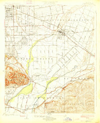
 1943 Downey1963 Print · USGSSoutheast Los Angeles County and northern Orange County appear here at the height of the mid-century boom. Researchers can trace the massive rail infrastructure of the Pacific Electric and locate landmarks like the County Hospital and Signal Hill.2 unique versions available
 - 1947 Map of Santa Ana, 1949 Print
 1947 Santa Ana1949 Print · USGSSouthern California is depicted here in the late forties, showing the expansion of the Inland Empire and the Orange County coast. Researchers can trace the early layout of Palm Springs or locate long-standing tribal lands like the Pala Indian Reservation and Rincon Indian Res.
 - 1948 Map of El Monte
 1948 El Monte1948 Print · USGSThe San Gabriel Valley is shown in the late 1940s as citrus groves gave way to mid-century neighborhoods. Genealogists can trace family roots through numerous local landmarks, including the Rosemead Lodge Sanitarium, Savannah Sch, and Rose Hill Memorial Park.
Showing maps 1-25 of 64
Top cities near Whittier
- Los Angeles historical maps
- Long Beach historical maps
- Anaheim historical maps
- Santa Ana historical maps
- Irvine historical maps
- Glendale historical maps
See more
Top neighborhoods of Whittier
Frequently asked questions
- What are the different types of historical maps available for Whittier?
- What is the oldest map of Whittier?
- Where can I purchase historical maps of Whittier for my home or office?
- Where can I download high-res historical maps of Whittier?
- Are there historical topographic maps available for Whittier?
- Is there historical aerial imagery available for Whittier?
- Where are historical maps of Whittier sourced from?