1990s Maps of Alturas, California
Explore 4 historic maps of Alturas from the 1990s. These maps offer a rare glimpse into what life looked like during the 1990s — showing old roads, neighborhoods, homes, and landmarks that have changed or disappeared over time.
Whether you're researching your family's past, planning a metal detecting trip, or studying how Alturas's landscape evolved across the 1990s, these high-resolution maps are a powerful tool for exploring the history of this region.
- Focus on a specific era: All maps on this page are from the 1990s, giving you a focused view of this time period.
- See what’s changed: Compare century-old streets, trails, and buildings to today's modern landscape using overlays and satellite layers.
- Research with precision: Use these maps for genealogy, historical research, land use analysis, or educational projects.
- View, download, or print: Maps are fully viewable online in high resolution, and can be downloaded or printed for your own records.
Start exploring Alturas's history through authentic maps from the 1990s. This is your window into the past.
Alturas, CA maps
(4)- 1990 Map of Alturas
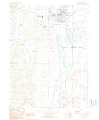 1990 Alturas1990 Print · USGSAlturas and the surrounding high desert wetlands are captured in detail during the late twentieth century. Researchers can trace the civic layout of the town, from the Alturas Rancheria to landmarks like Woods Place Dam and the Modoc High Sch.
 - 1990 Map of Mahogany Ridge
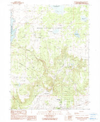 1990 Mahogany Ridge1990 Print · USGSModoc County’s high-country ranching and tribal lands are meticulously detailed in this late twentieth-century study. Researchers can trace the water infrastructure of the XL Ranch Indian Res and remote sites like Big Sage Dam and Daphnedale Park.
 - 1993 Map of Mahogany Ridge, 1996 Print
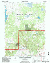 1993 Mahogany Ridge1996 Print · USGSNortheastern California's high-desert timberlands and ranching country are revealed here in the early nineties. Genealogists and historians can trace the borders of the X L Ranch Indian Res and land features like MAHOGANY RIDGE and Daphnedale Park.
 - 1993 Map of Alturas, 1997 Print
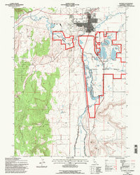 1993 Alturas1997 Print · USGSAlturas and its surroundings in the early nineties show a landscape shaped by the Pit River and careful water management. Researchers can locate the Alturas Rancheria, the Cem, and local landmarks like Signal Butte or the Woods Place Dam.
End of results
Showing maps 1-4 of 4
Frequently asked questions
- What are the different types of historical maps available for Alturas?
- What is the oldest map of Alturas?
- Where can I purchase historical maps of Alturas for my home or office?
- Where can I download high-res historical maps of Alturas?
- Are there historical topographic maps available for Alturas?
- Is there historical aerial imagery available for Alturas?
- Where are historical maps of Alturas sourced from?