1990s Maps of Fairport, California
Explore 2 historic maps of Fairport from the 1990s. These maps offer a rare glimpse into what life looked like during the 1990s — showing old roads, neighborhoods, homes, and landmarks that have changed or disappeared over time.
Whether you're researching your family's past, planning a metal detecting trip, or studying how Fairport's landscape evolved across the 1990s, these high-resolution maps are a powerful tool for exploring the history of this region.
- Focus on a specific era: All maps on this page are from the 1990s, giving you a focused view of this time period.
- See what’s changed: Compare century-old streets, trails, and buildings to today's modern landscape using overlays and satellite layers.
- Research with precision: Use these maps for genealogy, historical research, land use analysis, or educational projects.
- View, download, or print: Maps are fully viewable online in high resolution, and can be downloaded or printed for your own records.
Start exploring Fairport's history through authentic maps from the 1990s. This is your window into the past.
Fairport, CA maps
(2)- 1990 Map of Willow Ranch
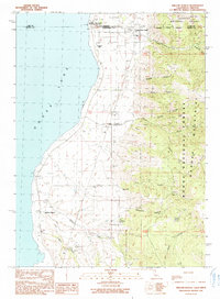 1990 Willow Ranch1990 Print · USGSThe California-Oregon borderlands come alive in this 1990 survey of the Goose Lake shoreline and the timbered slopes of the Warner Mountains. Genealogists and local historians can trace the foundations of Willow Ranch or locate family sites near Fairport and the Willow Ranch Cem.
 - 1993 Map of Willow Ranch, 1996 Print
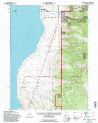 1993 Willow Ranch1996 Print · USGSNear the California-Oregon border in the early nineties, the eastern shore of Goose Lake supported a landscape of mountain forests and lakeside ranching. Genealogists and local historians can trace family-named sites like Willow Ranch Cem, the Fairport (Site), and the historic State Line Sch.
End of results
Showing maps 1-2 of 2
Top cities near Fairport
Frequently asked questions
- What are the different types of historical maps available for Fairport?
- What is the oldest map of Fairport?
- Where can I purchase historical maps of Fairport for my home or office?
- Where can I download high-res historical maps of Fairport?
- Are there historical topographic maps available for Fairport?
- Is there historical aerial imagery available for Fairport?
- Where are historical maps of Fairport sourced from?