Old Maps of Lower Rock Creek Summer Home Tract, Mono County for Genealogy
Trace your family roots with 10 historic maps of Lower Rock Creek Summer Home Tract. These high-res maps reveal old neighborhoods, homesites, landmarks, and streets — helping you uncover where your ancestors lived and how the area evolved over time.
- Explore historic neighborhoods: Identify where your relatives may have lived in the 1800s or 1900s.
- Compare maps over time: Trace the changes in streets, buildings, and landmarks for multi-generational research.
- Perfect for genealogy & ancestry research: Used by family historians and researchers to map out lineage and migration.
These maps are an incredible resource for exploring your personal connection to Lower Rock Creek Summer Home Tract's past.
Lower Rock Creek Summer Home Tract, Mono County maps
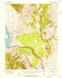
(10)- 1914 Map of Mt. Morrison
 1914 Mt. Morrison1914 Print · USGSCovers Lower Rock Creek Summer Home Tract, including Mammoth Lakes, Crowley Lake, and other nearby areas8 unique versions available
 - 1947 Map of Mariposa, 1948 Print
 1947 Mariposa1948 Print · USGSCovers Lower Rock Creek Summer Home Tract, including Mammoth Lakes, Oakhurst, and other nearby areas2 unique versions available
 - 1948 Map of Mariposa, 1951 Print
 1948 Mariposa1951 Print · USGSCovers Lower Rock Creek Summer Home Tract, including Mammoth Lakes, Oakhurst, and other nearby areas
 - 1953 Map of Casa Diablo Mtn, 1955 Print
 1953 Casa Diablo Mtn1955 Print · USGSCovers Lower Rock Creek Summer Home Tract, including Crowley Lake, Swall Meadows, and other nearby areas4 unique versions available
 - 1957 Map of Mariposa, 1966 Print
 1957 Mariposa1966 Print · USGSCovers Lower Rock Creek Summer Home Tract, including Mammoth Lakes, Oakhurst, and other nearby areas4 unique versions available
 - 1963 Map of Mariposa
 1963 Mariposa1963 Print · USGSCovers Lower Rock Creek Summer Home Tract, including Mammoth Lakes, Oakhurst, and other nearby areas
 - 1984 Map of Toms Place
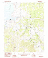 1984 Toms Place1984 Print · USGSCovers Lower Rock Creek Summer Home Tract, including Crowley Lake, Swall Meadows, and other nearby areas
 - 1988 Map of Benton Range
 1988 Benton Range1988 Print · USGSCovers Lower Rock Creek Summer Home Tract, including Mammoth Lakes, Crowley Lake, and other nearby areas2 unique versions available
 - 1990 Map of Toms Place
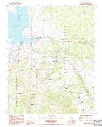 1990 Toms Place1990 Print · USGSCovers Lower Rock Creek Summer Home Tract, including Crowley Lake, Swall Meadows, and other nearby areas
 - 1994 Map of Toms Place, 1997 Print
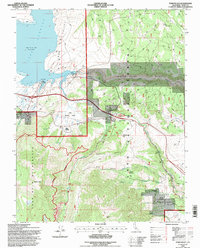 1994 Toms Place1997 Print · USGSCovers Lower Rock Creek Summer Home Tract, including Crowley Lake, Swall Meadows, and other nearby areas
End of results
Showing maps 1-10 of 10
Frequently asked questions
- What are the different types of historical maps available for Lower Rock Creek Summer Home Tract?
- What is the oldest map of Lower Rock Creek Summer Home Tract?
- Where can I purchase historical maps of Lower Rock Creek Summer Home Tract for my home or office?
- Where can I download high-res historical maps of Lower Rock Creek Summer Home Tract?
- Are there historical topographic maps available for Lower Rock Creek Summer Home Tract?
- Is there historical aerial imagery available for Lower Rock Creek Summer Home Tract?
- Where are historical maps of Lower Rock Creek Summer Home Tract sourced from?