1990s Maps of South Landing, California
Explore 2 historic maps of South Landing from the 1990s. These maps offer a rare glimpse into what life looked like during the 1990s — showing old roads, neighborhoods, homes, and landmarks that have changed or disappeared over time.
Whether you're researching your family's past, planning a metal detecting trip, or studying how South Landing's landscape evolved across the 1990s, these high-resolution maps are a powerful tool for exploring the history of this region.
- Focus on a specific era: All maps on this page are from the 1990s, giving you a focused view of this time period.
- See what’s changed: Compare century-old streets, trails, and buildings to today's modern landscape using overlays and satellite layers.
- Research with precision: Use these maps for genealogy, historical research, land use analysis, or educational projects.
- View, download, or print: Maps are fully viewable online in high resolution, and can be downloaded or printed for your own records.
Start exploring South Landing's history through authentic maps from the 1990s. This is your window into the past.
South Landing, CA maps
(2)- 1990 Map of Toms Place
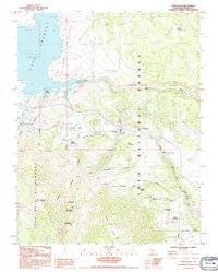 1990 Toms Place1990 Print · USGSHigh Sierra recreation and water management intersect in the 1990s as Crowley Lake meets the Owens River Gorge. Explore old mountain settlements like Toms Place and Swall Meadow or locate backcountry sites like Big Meadow Campground.
 - 1994 Map of Toms Place, 1997 Print
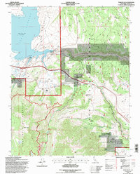 1994 Toms Place1997 Print · USGSThe Eastern Sierra near Mono County is captured here in the mid-nineties, showing the intersection of water infrastructure and wilderness. Genealogists and local historians can trace developments at Toms Place or locate family sites at Sky Meadow Ranch and Swall Meadow.
End of results
Showing maps 1-2 of 2
Top cities near South Landing
- Mammoth Lakes historical maps
- West Bishop historical maps
- Crowley Lake historical maps
- Round Valley historical maps
- Mesa historical maps
- Swall Meadows historical maps
See more
Frequently asked questions
- What are the different types of historical maps available for South Landing?
- What is the oldest map of South Landing?
- Where can I purchase historical maps of South Landing for my home or office?
- Where can I download high-res historical maps of South Landing?
- Are there historical topographic maps available for South Landing?
- Is there historical aerial imagery available for South Landing?
- Where are historical maps of South Landing sourced from?