1990s Maps of Virginia Lakes, California
Explore 2 historic maps of Virginia Lakes from the 1990s. These maps offer a rare glimpse into what life looked like during the 1990s — showing old roads, neighborhoods, homes, and landmarks that have changed or disappeared over time.
Whether you're researching your family's past, planning a metal detecting trip, or studying how Virginia Lakes's landscape evolved across the 1990s, these high-resolution maps are a powerful tool for exploring the history of this region.
- Focus on a specific era: All maps on this page are from the 1990s, giving you a focused view of this time period.
- See what’s changed: Compare century-old streets, trails, and buildings to today's modern landscape using overlays and satellite layers.
- Research with precision: Use these maps for genealogy, historical research, land use analysis, or educational projects.
- View, download, or print: Maps are fully viewable online in high resolution, and can be downloaded or printed for your own records.
Start exploring Virginia Lakes's history through authentic maps from the 1990s. This is your window into the past.
Virginia Lakes, CA maps
(2)- 1990 Map of Dunderberg Peak
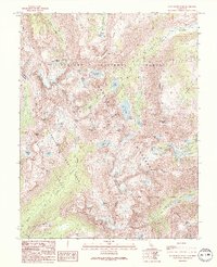 1990 Dunderberg Peak1990 Print · USGSThe high Sierra Nevada crest comes into focus in 1990, where the Yosemite boundary meets the Hoover Wilderness. Trace remote mining Prospects and high-altitude routes like Kavanaugh Ridge Road and the Cattle Creek Trail.
 - 1994 Map of Dunderberg Peak, 1997 Print
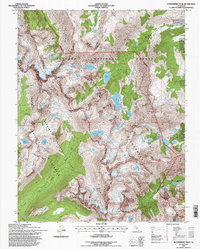 1994 Dunderberg Peak1997 Print · USGSThe Sierra Nevada high country in the mid-1990s reveals a complex intersection of wilderness boundaries and alpine peaks. Hikers and historians can trace the trail networks around Lundy Lake, locate the prospect near Dunderberg Peak, and explore the headwaters of Virginia Creek.
End of results
Showing maps 1-2 of 2
Frequently asked questions
- What are the different types of historical maps available for Virginia Lakes?
- What is the oldest map of Virginia Lakes?
- Where can I purchase historical maps of Virginia Lakes for my home or office?
- Where can I download high-res historical maps of Virginia Lakes?
- Are there historical topographic maps available for Virginia Lakes?
- Is there historical aerial imagery available for Virginia Lakes?
- Where are historical maps of Virginia Lakes sourced from?