1890s Maps of Feather River Park, California
Explore 5 historic maps of Feather River Park from the 1890s. These maps offer a rare glimpse into what life looked like during the 1890s — showing old roads, neighborhoods, homes, and landmarks that have changed or disappeared over time.
Whether you're researching your family's past, planning a metal detecting trip, or studying how Feather River Park's landscape evolved across the 1890s, these high-resolution maps are a powerful tool for exploring the history of this region.
- Focus on a specific era: All maps on this page are from the 1890s, giving you a focused view of this time period.
- See what’s changed: Compare century-old streets, trails, and buildings to today's modern landscape using overlays and satellite layers.
- Research with precision: Use these maps for genealogy, historical research, land use analysis, or educational projects.
- View, download, or print: Maps are fully viewable online in high resolution, and can be downloaded or printed for your own records.
Start exploring Feather River Park's history through authentic maps from the 1890s. This is your window into the past.
Feather River Park, CA maps
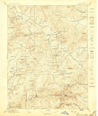
(5)- 1891 Map of Downieville
 1891 Downieville1891 Print · USGSThe gold-bearing ridges of the Northern Sierra come alive in the 1890s, when mining camps and high-country ranches defined the local economy. Researchers can trace the Sierra Turnpike and locate historic claims like the Empire Mine or the settlement of Whiskey Diggings.
 - 1893 Map of Downieville
 1893 Downieville1893 Print · USGSThe northern Sierra Nevada's gold country is revealed here during its late nineteenth-century mining peak. Researchers can trace historic claims and family outposts from Whiskey Diggings and Poker Flat to the Plumas Eureka mine.
 - 1895 Map of Downieville
 1895 Downieville1895 Print · USGSThe high Sierra mining districts of the 1890s are captured here during a peak era of resource extraction. Researchers can trace historic gold camps and industrial sites like Whiskey Diggings, the Plumas Eureka mine, and Poker Flat.
 - 1896 Map of Downieville
 1896 Downieville1896 Print · USGSThe northern Sierra Nevada comes alive in this 1890s survey of the Feather and Yuba River watersheds. Genealogists and historians can trace gold-rush era settlements from Quincy to Downieville, locating historic sites like Whiskey Diggings and the Empire Mine.
 - 1897 Map of Downieville
 1897 Downieville1897 Print · USGSThe northern Sierra Nevada's rugged gold country comes to life in the late nineteenth century, showing the dense network of camps and mines around Downieville. Researchers can trace the exact locations of historic operations like the Young America Mine and long-standing settlements like Howland Flat and Quincy.7 unique versions available
End of results
Showing maps 1-5 of 5
Top cities near Feather River Park
Frequently asked questions
- What are the different types of historical maps available for Feather River Park?
- What is the oldest map of Feather River Park?
- Where can I purchase historical maps of Feather River Park for my home or office?
- Where can I download high-res historical maps of Feather River Park?
- Are there historical topographic maps available for Feather River Park?
- Is there historical aerial imagery available for Feather River Park?
- Where are historical maps of Feather River Park sourced from?