1950s Maps of Rodgers Flat, California
Explore 2 historic maps of Rodgers Flat from the 1950s. These maps offer a rare glimpse into what life looked like during the 1950s — showing old roads, neighborhoods, homes, and landmarks that have changed or disappeared over time.
Whether you're researching your family's past, planning a metal detecting trip, or studying how Rodgers Flat's landscape evolved across the 1950s, these high-resolution maps are a powerful tool for exploring the history of this region.
- Focus on a specific era: All maps on this page are from the 1950s, giving you a focused view of this time period.
- See what’s changed: Compare century-old streets, trails, and buildings to today's modern landscape using overlays and satellite layers.
- Research with precision: Use these maps for genealogy, historical research, land use analysis, or educational projects.
- View, download, or print: Maps are fully viewable online in high resolution, and can be downloaded or printed for your own records.
Start exploring Rodgers Flat's history through authentic maps from the 1950s. This is your window into the past.
Rodgers Flat, CA maps
(2)- 1957 Map of Pulga, 1959 Print
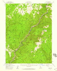 1957 Pulga1959 Print · USGSThe Feather River Canyon comes alive in the late 1950s as a corridor of rail transit and hydroelectric development. Genealogists and historians can trace rail stops like Pulga and Storrie or locate remote sites like Johnson Cabin and Stones Mine.3 unique versions available
 - 1958 Map of Chico, 1962 Print
 1958 Chico1962 Print · USGSMid-century Northern California comes to life across the Central Valley and high Sierras as the postwar economy transformed the landscape. Trace the rail lines of the Southern Pacific RR, locate family roots near Chico Cem, or explore the early layout of Paradise and Beale Air Force Base.4 unique versions available
End of results
Showing maps 1-2 of 2
Frequently asked questions
- What are the different types of historical maps available for Rodgers Flat?
- What is the oldest map of Rodgers Flat?
- Where can I purchase historical maps of Rodgers Flat for my home or office?
- Where can I download high-res historical maps of Rodgers Flat?
- Are there historical topographic maps available for Rodgers Flat?
- Is there historical aerial imagery available for Rodgers Flat?
- Where are historical maps of Rodgers Flat sourced from?