1950s Maps of Riverside, California
Explore 14 historic maps of Riverside from the 1950s. These maps offer a rare glimpse into what life looked like during the 1950s — showing old roads, neighborhoods, homes, and landmarks that have changed or disappeared over time.
Whether you're researching your family's past, planning a metal detecting trip, or studying how Riverside's landscape evolved across the 1950s, these high-resolution maps are a powerful tool for exploring the history of this region.
- Focus on a specific era: All maps on this page are from the 1950s, giving you a focused view of this time period.
- See what’s changed: Compare century-old streets, trails, and buildings to today's modern landscape using overlays and satellite layers.
- Research with precision: Use these maps for genealogy, historical research, land use analysis, or educational projects.
- View, download, or print: Maps are fully viewable online in high resolution, and can be downloaded or printed for your own records.
Start exploring Riverside's history through authentic maps from the 1950s. This is your window into the past.
Riverside, CA maps
(14)- 1953 Map of San Bernardino
 1953 San Bernardino1953 Print · USGSSouthern California underwent massive post-war growth as suburban sprawl reached the foothills of the San Bernardino Mountains. Genealogists and historians can trace the rail-and-road roots of the Inland Empire through the Union Pacific RR and Lake Arrowhead resorts.2 unique versions available
 - 1953 Map of Fontana, 1955 Print
 1953 Fontana1955 Print · USGSThe Inland Empire industrial corridor comes alive in this mid-century survey as the Kaiser Steel Plant and sprawling rail networks reshape the valley. Genealogists and local historians can trace the foundations of Fontana through its neighborhood landmarks, from Bloomington Sch to the Crestmore Quarry.2 unique versions available
 - 1953 Map of Steele Peak, 1955 Print
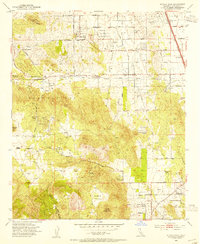 1953 Steele Peak1955 Print · USGSRiverside County at the dawn of the fifties reveals a transition from deep-shaft mining to a burgeoning ranching economy. Researchers can trace historic claims like the Gavilan Mine or explore early local hubs such as Val Verde and the Wagonwheel Ranch.2 unique versions available
 - 1953 Map of Riverside East, 1955 Print
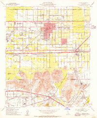
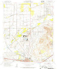
 1953 Riverside East1955 Print · USGSRiverside was evolving from a citrus center into a strategic military and educational hub during the mid-fifties. Researchers can trace the layout of March Air Force Base, early campuses like UC Riverside, and local schools such as Fairmont Sch.2 unique versions available
 - 1953 Map of Riverside West, 1955 Print
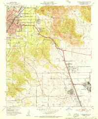
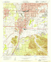
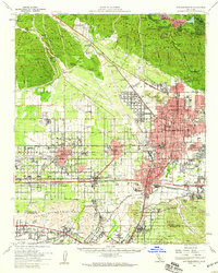
 1953 Riverside West1955 Print · USGSRiverside during the early fifties reveals a landscape shaped by historic land grants and a burgeoning citrus and rail economy. Genealogists and researchers can locate family sites near Olivewood Cem, the Sherman Indian Institute, and the Arlington Station rail yard.2 unique versions available
 - 1954 Map of Corona North, 1955 Print
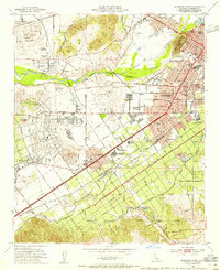
 1954 Corona North1955 Print · USGSThe northern Chino Basin and the Santa Ana River valley are captured here in the mid-fifties, showing a mix of military installations and citrus groves. Genealogists and local historians can trace family-named sites like Fuller Ranch, early education at East Vale School, and the grounds of the Naval Hospital.2 unique versions available
 - 1954 Map of San Bernardino South, 1955 Print
 1954 San Bernardino South1955 Print · USGSThe Inland Empire is shown at a pivotal moment of post-war development, where citrus groves meet expanding rail and military hubs. Genealogists and historians can locate legacy sites like Agua Mansa Cemetery, the Union Academy, and the early footprint of Norton Air Force Base.2 unique versions available
 - 1954 Map of San Bernardino, 1959 Print
 1954 San Bernardino1959 Print · USGSSan Bernardino and the booming valley floor are shown in the mid-fifties as the citrus groves began giving way to suburban and industrial growth. Researchers can trace family roots through Waterman Gardens, find small regional hubs like Miro-Fontana Airport, or locate the historic Agua Mansa Cem.2 unique versions available
 - 1956 Map of San Bernardino
 1956 San Bernardino1956 Print · USGSSouthern California's Inland Empire and High Desert come into focus in the mid-fifties as agriculture gives way to suburban and military growth. Trace early rail lines like the Pacific Electric or find remote landmarks like Camp Rock Mine and George AFB.
 - 1956 Map of Santa Ana
 1956 Santa Ana1956 Print · USGSSouthern California underwent massive mid-century transformation as suburban growth met major military and water projects. Trace the postwar expansion of Santa Ana and Riverside, the layout of Camp Pendleton, and the path of the Colorado River Aqueduct.
 - 1957 Map of San Bernardino
 1957 San Bernardino1957 Print · USGSSouthern California's Inland Empire and High Desert met during the postwar expansion of the late fifties. Genealogists and historians can trace the growth of San Bernardino and Redlands alongside remote landmarks like Edwards AFB and the Camp Rock Mine.
 - 1958 Map of San Bernardino, 1975 Print
 1958 San Bernardino1975 Print · USGSSouthern California’s Inland Empire and High Desert come into focus during the mid-century boom, showing the rise of suburbs and massive military installations. Researchers can trace the rail networks of the Union Pacific RR or locate landmarks like Norton AFB and Big Bear Lake.
 - 1959 Map of San Bernardino
 1959 San Bernardino1959 Print · USGSSouthern California underwent a massive transformation in the late fifties as suburban growth and military power reshaped the desert and valley. Researchers can trace the legacy of the Union Pacific Railroad and locate early footprints of Joshua Tree National Monument and Edwards Air Force Base.
 - 1959 Map of Santa Ana, 1971 Print
 1959 Santa Ana1971 Print · USGSSouthern California is captured in a decade of transformation, from the Orange County coast to the desert floor. Researchers can trace the mid-century footprints of Camp Pendleton, March Air Force Base, and the original Ortega Highway.3 unique versions available
End of results
Showing maps 1-14 of 14
Top cities near Riverside
- Fontana historical maps
- Moreno Valley historical maps
- Ontario historical maps
- Rancho Cucamonga historical maps
- Corona historical maps
- Rialto historical maps
See more
Top neighborhoods of Riverside
- Tilden-Coil Constructors Plaza historical maps
- Riverside Junction historical maps
- Presidential Park historical maps
- Arlington Heights historical maps
- Arlington Station historical maps
- Canyon Crest historical maps
See more
Frequently asked questions
- What are the different types of historical maps available for Riverside?
- What is the oldest map of Riverside?
- Where can I purchase historical maps of Riverside for my home or office?
- Where can I download high-res historical maps of Riverside?
- Are there historical topographic maps available for Riverside?
- Is there historical aerial imagery available for Riverside?
- Where are historical maps of Riverside sourced from?