1970s Maps of Loma Linda, California
Explore 2 historic maps of Loma Linda from the 1970s. These maps offer a rare glimpse into what life looked like during the 1970s — showing old roads, neighborhoods, homes, and landmarks that have changed or disappeared over time.
Whether you're researching your family's past, planning a metal detecting trip, or studying how Loma Linda's landscape evolved across the 1970s, these high-resolution maps are a powerful tool for exploring the history of this region.
- Focus on a specific era: All maps on this page are from the 1970s, giving you a focused view of this time period.
- See what’s changed: Compare century-old streets, trails, and buildings to today's modern landscape using overlays and satellite layers.
- Research with precision: Use these maps for genealogy, historical research, land use analysis, or educational projects.
- View, download, or print: Maps are fully viewable online in high resolution, and can be downloaded or printed for your own records.
Start exploring Loma Linda's history through authentic maps from the 1970s. This is your window into the past.
Loma Linda, CA maps
(2)- 1975 Map of Redlands, 1977 Print
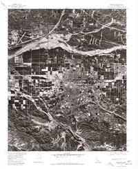 1975 Redlands1977 Print · USGSRedlands and the San Bernardino Valley are documented in the mid-1970s via this detailed orthophotograph survey. Researchers can trace the layout of Norton Air Force Base or follow the natural course of Santa Ana Wash and San Timoteo Canyon.
 - 1975 Map of San Bernardino South, 1977 Print
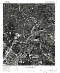 1975 San Bernardino South1977 Print · USGSSouthern California's Inland Empire is shown at a moment of intense growth in the mid-seventies, captured through aerial photography. Researchers can trace the industrial layouts of Colton and Rialto or locate mid-century developments in Loma Linda and Grand Terrace.
End of results
Showing maps 1-2 of 2
Top cities near Loma Linda
- Riverside historical maps
- Fontana historical maps
- Moreno Valley historical maps
- Rialto historical maps
- Jurupa Valley historical maps
- Redlands historical maps
See more
Top neighborhoods of Loma Linda
Frequently asked questions
- What are the different types of historical maps available for Loma Linda?
- What is the oldest map of Loma Linda?
- Where can I purchase historical maps of Loma Linda for my home or office?
- Where can I download high-res historical maps of Loma Linda?
- Are there historical topographic maps available for Loma Linda?
- Is there historical aerial imagery available for Loma Linda?
- Where are historical maps of Loma Linda sourced from?