1930s Maps of Ontario Ranch, Ontario
Explore 2 historic maps of Ontario Ranch from the 1930s. These maps offer a rare glimpse into what life looked like during the 1930s — showing old roads, neighborhoods, homes, and landmarks that have changed or disappeared over time.
Whether you're researching your family's past, planning a metal detecting trip, or studying how Ontario Ranch's landscape evolved across the 1930s, these high-resolution maps are a powerful tool for exploring the history of this region.
- Focus on a specific era: All maps on this page are from the 1930s, giving you a focused view of this time period.
- See what’s changed: Compare century-old streets, trails, and buildings to today's modern landscape using overlays and satellite layers.
- Research with precision: Use these maps for genealogy, historical research, land use analysis, or educational projects.
- View, download, or print: Maps are fully viewable online in high resolution, and can be downloaded or printed for your own records.
Start exploring Ontario Ranch's history through authentic maps from the 1930s. This is your window into the past.
Ontario Ranch, Ontario maps
(2)- 1933 Map of Prado
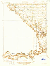 1933 Prado1933 Print · USGSIn the early 1930s, the Chino Valley was a hub of irrigation canals and rail-side settlements before later development changed the landscape. Genealogists and historians can trace old homesteads like Pellissier Ranch and schools like the California Junior Republic School.
 - 1933 Map of Ontario
 1933 Ontario1933 Print · USGSThe citrus heart of the Inland Empire comes into focus in the early thirties as it transitions into a major transit hub. Genealogists and historians can trace the early footprints of Ontario, Upland, and Chino, while locating landmarks like Bellevue Cem and the Pacific Electric line.
End of results
Showing maps 1-2 of 2
Frequently asked questions
- What are the different types of historical maps available for Ontario Ranch?
- What is the oldest map of Ontario Ranch?
- Where can I purchase historical maps of Ontario Ranch for my home or office?
- Where can I download high-res historical maps of Ontario Ranch?
- Are there historical topographic maps available for Ontario Ranch?
- Is there historical aerial imagery available for Ontario Ranch?
- Where are historical maps of Ontario Ranch sourced from?