Old Maps of Farr, Carlsbad for Genealogy
Trace your family roots with 18 historic maps of Farr. These high-res maps reveal old neighborhoods, homesites, landmarks, and streets — helping you uncover where your ancestors lived and how the area evolved over time.
- Explore historic neighborhoods: Identify where your relatives may have lived in the 1800s or 1900s.
- Compare maps over time: Trace the changes in streets, buildings, and landmarks for multi-generational research.
- Perfect for genealogy & ancestry research: Used by family historians and researchers to map out lineage and migration.
These maps are an incredible resource for exploring your personal connection to Farr's past.
Farr, Carlsbad maps
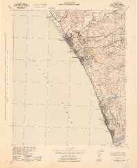
(18)- 1893 Map of Oceanside
 1893 Oceanside1893 Print · USGSCovers Farr, including Oceanside, Carlsbad, and other nearby areas2 unique versions available
 - 1898 Map of Oceanside, 1955 Print
 1898 Oceanside1955 Print · USGSCovers Farr, including Oceanside, Carlsbad, and other nearby areas5 unique versions available
 - 1901 Map of Oceanside
 1901 Oceanside1901 Print · USGSCovers Farr, including Oceanside, Carlsbad, and other nearby areas8 unique versions available
 - 1901 Map of San Luis Rey
 1901 San Luis Rey1901 Print · USGSCovers Farr, including San Diego, Oceanside, and other nearby areas8 unique versions available
 - 1904 Map of Southern California Sheet No. 2
 1904 Southern California Sheet No. 21904 Print · USGSCovers Farr, including Tijuana, San Diego, and other nearby areas5 unique versions available
 - 1942 Map of Oceanside
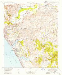
 1942 Oceanside1942 Print · USGSCovers Farr, including Oceanside, Carlsbad, and other nearby areas
 - 1947 Map of Santa Ana, 1949 Print
 1947 Santa Ana1949 Print · USGSCovers Farr, including San Diego, Anaheim, and other nearby areas
 - 1948 Map of San Luis Rey, 1955 Print
 1948 San Luis Rey1955 Print · USGSCovers Farr, including Oceanside, Carlsbad, and other nearby areas3 unique versions available
 - 1949 Map of San Luis Rey
 1949 San Luis Rey1949 Print · USGSCovers Farr, including Oceanside, Carlsbad, and other nearby areas
 - 1949 Map of Santa Ana
 1949 Santa Ana1949 Print · USGSCovers Farr, including San Diego, Anaheim, and other nearby areas
 - 1956 Map of Santa Ana
 1956 Santa Ana1956 Print · USGSCovers Farr, including San Diego, Anaheim, and other nearby areas
 - 1959 Map of Santa Ana, 1971 Print
 1959 Santa Ana1971 Print · USGSCovers Farr, including San Diego, Anaheim, and other nearby areas3 unique versions available
 - 1960 Map of Santa Ana
 1960 Santa Ana1960 Print · USGSCovers Farr, including San Diego, Anaheim, and other nearby areas2 unique versions available
 - 1965 Map of Santa Ana
 1965 Santa Ana1965 Print · USGSCovers Farr, including San Diego, Anaheim, and other nearby areas
 - 1968 Map of San Luis Rey, 1969 Print
 1968 San Luis Rey1969 Print · USGSCovers Farr, including Oceanside, Carlsbad, and other nearby areas3 unique versions available
 - 1982 Map of Oceanside, 1983 Print
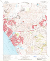
 1982 Oceanside1983 Print · USGSCovers Farr, including San Diego, Oceanside, and other nearby areas2 unique versions available
 - 1997 Map of San Luis Rey, 2000 Print
 1997 San Luis Rey2000 Print · USGSCovers Farr, including Oceanside, Carlsbad, and other nearby areas
 - 2022 Map of San Luis Rey, 2022 Print
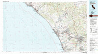
 2022 San Luis Rey2022 Print · USGSCovers Farr, including Oceanside, Carlsbad, and other nearby areas
End of results
Showing maps 1-18 of 18
Frequently asked questions
- What are the different types of historical maps available for Farr?
- What is the oldest map of Farr?
- Where can I purchase historical maps of Farr for my home or office?
- Where can I download high-res historical maps of Farr?
- Are there historical topographic maps available for Farr?
- Is there historical aerial imagery available for Farr?
- Where are historical maps of Farr sourced from?