1990s Maps of Los Arboles, Escondido
Explore 2 historic maps of Los Arboles from the 1990s. These maps offer a rare glimpse into what life looked like during the 1990s — showing old roads, neighborhoods, homes, and landmarks that have changed or disappeared over time.
Whether you're researching your family's past, planning a metal detecting trip, or studying how Los Arboles's landscape evolved across the 1990s, these high-resolution maps are a powerful tool for exploring the history of this region.
- Focus on a specific era: All maps on this page are from the 1990s, giving you a focused view of this time period.
- See what’s changed: Compare century-old streets, trails, and buildings to today's modern landscape using overlays and satellite layers.
- Research with precision: Use these maps for genealogy, historical research, land use analysis, or educational projects.
- View, download, or print: Maps are fully viewable online in high resolution, and can be downloaded or printed for your own records.
Start exploring Los Arboles's history through authentic maps from the 1990s. This is your window into the past.
Los Arboles, Escondido maps
(2)- 1996 Map of Valley Center, 2000 Print
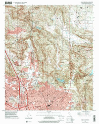 1996 Valley Center2000 Print · USGSNorthern San Diego County in the mid-nineties shows the expanding urban interface of Escondido and rural Valley Center. Genealogists and local historians can trace the development of neighborhood schools like Conway Sch and landmarks like Valley Center Cem.
 - 1996 Map of Escondido, 2001 Print
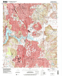 1996 Escondido2001 Print · USGSInland San Diego County entered the late nineties as a thriving suburban frontier centered around Escondido. Trace the growth of Rancho Bernardo and Poway alongside local landmarks like the San Diego Wild Animal Park and Lake Hodges.
End of results
Showing maps 1-2 of 2
Frequently asked questions
- What are the different types of historical maps available for Los Arboles?
- What is the oldest map of Los Arboles?
- Where can I purchase historical maps of Los Arboles for my home or office?
- Where can I download high-res historical maps of Los Arboles?
- Are there historical topographic maps available for Los Arboles?
- Is there historical aerial imagery available for Los Arboles?
- Where are historical maps of Los Arboles sourced from?