1960s Maps of Kentwood-In-The-Pines, Julian
Explore 4 historic maps of Kentwood-In-The-Pines from the 1960s. These maps offer a rare glimpse into what life looked like during the 1960s — showing old roads, neighborhoods, homes, and landmarks that have changed or disappeared over time.
Whether you're researching your family's past, planning a metal detecting trip, or studying how Kentwood-In-The-Pines's landscape evolved across the 1960s, these high-resolution maps are a powerful tool for exploring the history of this region.
- Focus on a specific era: All maps on this page are from the 1960s, giving you a focused view of this time period.
- See what’s changed: Compare century-old streets, trails, and buildings to today's modern landscape using overlays and satellite layers.
- Research with precision: Use these maps for genealogy, historical research, land use analysis, or educational projects.
- View, download, or print: Maps are fully viewable online in high resolution, and can be downloaded or printed for your own records.
Start exploring Kentwood-In-The-Pines's history through authentic maps from the 1960s. This is your window into the past.
Kentwood-In-The-Pines, Julian maps
(4)- 1960 Map of Santa Ana
 1960 Santa Ana1960 Print · USGSSouthern California's coastal plains and inland deserts meet in this mid-century survey of the burgeoning Orange and Riverside county corridors. Researchers can trace the layout of early freeway systems, find tribal lands like the Soboba Indian Reservation, and locate military landmarks such as March Field.2 unique versions available
 - 1960 Map of Santa Ysabel, 1962 Print
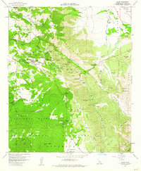
 1960 Santa Ysabel1962 Print · USGSSan Diego's backcountry in the early sixties was a landscape of historic stagecoach stops, gold mines, and mountain ranching. Genealogists and historians can trace old landmarks like the Butterfield Stage Station, the Banner Queen Mine, and the Spencer Valley Sch.3 unique versions available
 - 1960 Map of Julian, 1962 Print
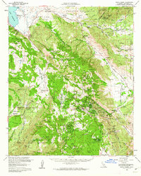
 1960 Julian1962 Print · USGSJulian and its surrounding mountain camps are captured during the early 1960s, showing a landscape defined by its mining history and high-country ranching. Genealogists and historians can locate numerous named claims like the Roosevelt Mine and the Golden Chariot Mine, alongside the Banner Queen Trading Post.5 unique versions available
 - 1965 Map of Santa Ana
 1965 Santa Ana1965 Print · USGSSouthern California is captured in a decade of rapid growth, showing the coastal expansion from Santa Ana down to Oceanside. Genealogists and historians can trace the mid-century development of places like Garden Grove or the rural reaches of Escondido and the Palomar Observatory.
End of results
Showing maps 1-4 of 4
Top cities near Kentwood-In-The-Pines
- San Diego Country Estates historical maps
- Julian historical maps
- Descanso historical maps
- Mount Laguna historical maps
Frequently asked questions
- What are the different types of historical maps available for Kentwood-In-The-Pines?
- What is the oldest map of Kentwood-In-The-Pines?
- Where can I purchase historical maps of Kentwood-In-The-Pines for my home or office?
- Where can I download high-res historical maps of Kentwood-In-The-Pines?
- Are there historical topographic maps available for Kentwood-In-The-Pines?
- Is there historical aerial imagery available for Kentwood-In-The-Pines?
- Where are historical maps of Kentwood-In-The-Pines sourced from?