1990s Maps of National City, California
Explore 3 historic maps of National City from the 1990s. These maps offer a rare glimpse into what life looked like during the 1990s — showing old roads, neighborhoods, homes, and landmarks that have changed or disappeared over time.
Whether you're researching your family's past, planning a metal detecting trip, or studying how National City's landscape evolved across the 1990s, these high-resolution maps are a powerful tool for exploring the history of this region.
- Focus on a specific era: All maps on this page are from the 1990s, giving you a focused view of this time period.
- See what’s changed: Compare century-old streets, trails, and buildings to today's modern landscape using overlays and satellite layers.
- Research with precision: Use these maps for genealogy, historical research, land use analysis, or educational projects.
- View, download, or print: Maps are fully viewable online in high resolution, and can be downloaded or printed for your own records.
Start exploring National City's history through authentic maps from the 1990s. This is your window into the past.
National City, CA maps
(3)- 1996 Map of Point Loma, 2001 Print
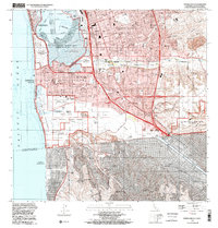
 1996 Point Loma2001 Print · USGSSan Diego and Coronado are shown here in the mid-nineties, capturing a landscape defined by massive naval installations and coastal neighborhoods. Researchers can trace the layout of Naval Air Station North Island, Balboa Park, and schools like Collier Jr High Sch.
 - 1996 Map of National City, 2001 Print
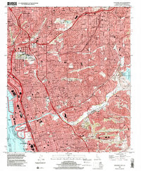 1996 National City2001 Print · USGSThe South Bay and San Diego's eastern suburbs are captured here during a period of peak urban development. Researchers can trace neighborhood growth through Lincoln Acres and Bonita or find family landmarks like Mount Hope Cemetery.
 - 1996 Map of Imperial Beach, 2002 Print
 1996 Imperial Beach2002 Print · USGSCoastal San Diego County at the turn of the millennium shows a bustling borderland where intense suburban growth meets protected Pacific estuaries. Genealogists and historians can locate residential landmarks like Mt Olivet Cem, trace the route of the San Diego and Arizona Eastern RR, and study the massive Salt Evaporators on the bay.
End of results
Showing maps 1-3 of 3
Top cities near National City
- San Diego historical maps
- Chula Vista historical maps
- El Cajon historical maps
- La Mesa historical maps
- Santee historical maps
- La Presa historical maps
See more
Top neighborhoods of National City
Frequently asked questions
- What are the different types of historical maps available for National City?
- What is the oldest map of National City?
- Where can I purchase historical maps of National City for my home or office?
- Where can I download high-res historical maps of National City?
- Are there historical topographic maps available for National City?
- Is there historical aerial imagery available for National City?
- Where are historical maps of National City sourced from?