Old Maps of Birdland, Sunnyvale for Hiking & Exploration
Hike through history with 36 historic maps of Birdland. Explore old trails, ghost towns, and forgotten backroads — perfect for outdoor adventurers and local explorers.
- Rediscover forgotten places: Map out old mining camps, roads, and footpaths that no longer exist on modern maps.
- Layer with modern tools: Combine with LiDAR or satellite views to plan hikes through historical terrain.
- Made for exploration: Popular among hikers, overlanders, and local history lovers.
Use these maps to find adventure and explore the hidden past of Birdland.
Birdland, Sunnyvale maps
(36)- 1889 Map of San Jose, 1939 Print
 1889 San Jose1939 Print · USGSSanta Clara County during the late nineteenth century was a mosaic of historic ranchos and developing rail lines. Genealogists can trace family footprints through early settlements like Milpitas, Berryessa, and the grounds of the Santa Clara Co. Alms House.2 unique versions available
 - 1897 Map of San Jose
 1897 San Jose1897 Print · USGSThe Santa Clara Valley at the close of the nineteenth century is captured here as a landscape of vast ranchos and emerging rail towns. Genealogists can trace family lands across the Enright Tract or locate ancestors at the County Infirmary, Agnew, and Willow Glen.
 - 1897 Map of Palo Alto
 1897 Palo Alto1897 Print · USGSThe San Francisco Peninsula and Santa Clara Valley emerge in the late nineteenth century as academic and rail hubs. Trace the early footprints of Stanford University, the primary line of the Southern Pacific RR, and the transition of old ranchos like La Purisima Concepcion.
 - 1899 Map of San Jose
 1899 San Jose1899 Print · USGSThe Santa Clara Valley at the end of the century reveals a landscape of ranchos and growing rail hubs. Genealogists can trace family names and institutions from San Jose to the Santa Clara Co. Alms House and Agnew asylum.6 unique versions available
 - 1899 Map of Palo Alto
 1899 Palo Alto1899 Print · USGSThe San Francisco Peninsula was entering a period of rapid development in the 1890s as railroad towns began to flourish around the new Stanford University campus. You can trace early property lines across Pastoria de las Borregas or locate nineteenth-century landings like Cooley Landing and Jagel Landing.11 unique versions available
 - 1902 Map of Santa Cruz
 1902 Santa Cruz1902 Print · USGSCoastal California at the end of the Victorian era reveals a landscape of redwood forests, early university towns, and remote Pacific outposts. Genealogists and historians can trace the early rail corridors through Boulder Creek and Felton or locate coastal landmarks like Pigeon Point and Halfmoon Bay.9 unique versions available
 - 1941 Map of Palo Alto
 1941 Palo Alto1941 Print · USGSThe Peninsula and Santa Clara Valley are seen here in the early 1940s, just as the region began its mid-century transformation. Researchers can trace the layout of Stanford University, the military grounds of Moffett Field, and local landmarks like Flood Park.
 - 1943 Map of Palo Alto
 1943 Palo Alto1943 Print · USGSThe San Francisco Peninsula was still a region of orchards and academic outposts in the years following the Great Depression. Researchers can trace the development of early Silicon Valley through the Southern Pacific line and family landmarks like Duveneck Ranch and the Whisman Dist School.
 - 1943 Map of San Jose
 1943 San Jose1943 Print · USGSThe Santa Clara Valley is seen here in the early 1940s, showing a landscape of orchards and rail junctions. Trace family roots in San Jose or locate old landmarks like the Agnew State Hospital and Oak Hill Memorial Park.
 - 1947 Map of San Francisco, 1948 Print
 1947 San Francisco1948 Print · USGSThe Bay Area in the late 1940s reveals a region transitioning from wartime intensity to post-war suburban growth. Trace the historic rail lines of the Southern Pacific RR or locate early military footprints at Fort Funston and Moffett Field.
 - 1947 Map of San Jose, 1948 Print
 1947 San Jose1948 Print · USGSNorthern California's heartland is captured here just after the war, showing the rapid growth of the Santa Clara and Central Valleys. Researchers can trace the legacy of rail and water at Castle Air Force Base, Stockton, and the Hetch Hetchy Aqueduct.
 - 1948 Map of San Francisco, 1951 Print
 1948 San Francisco1951 Print · USGSThe Bay Area in the late 1940s reveals a landscape defined by rapid post-war growth and a heavy military presence at the Golden Gate. Trace the development of early trans-bay infrastructure like the Oakland-Bay Bridge and historic coastal defense sites such as Fort Funston and Alcatraz Island.
 - 1948 Map of Palo Alto, 1956 Print
 1948 Palo Alto1956 Print · USGSThe San Francisco Peninsula is captured here during its postwar transformation into a suburban and technological hub. Genealogists and local historians can trace early neighborhood boundaries near Stanford University, the sprawling Moffet Naval Air Station, and family landmarks like O'Neal Ranch.
 - 1953 Map of San Jose West, 1955 Print
 1953 San Jose West1955 Print · USGSSanta Clara and San Jose are shown during a period of significant growth in the early fifties, as residential tracts began to replace valley orchards. Researchers can locate family landmarks like Santa Clara Cemetery, the Winchester Mystery House, and San Jose State College.
 - 1953 Map of Cupertino, 1955 Print
 1953 Cupertino1955 Print · USGSThe Santa Clara Valley is seen here in the early fifties, still balanced between its agricultural roots and industrial growth. Genealogists and historians can trace the footprint of Loyola Corners, the historic Madronia Cem, and the massive Permanente Cement Plant.
 - 1953 Map of San Jose, 1959 Print
 1953 San Jose1959 Print · USGSThe Santa Clara Valley comes alive in the mid-1950s, showing the transition from agricultural ranch lands to a growing suburban and industrial hub. Researchers can trace ancestral locations near Agnew State Hospital, the original village of Alviso, or the early campus of San Jose State College.
 - 1955 Map of San Francisco
 1955 San Francisco1955 Print · USGSThe San Francisco Bay Area and central coast are captured during the postwar boom as suburbs and infrastructure expanded rapidly. Trace the development of local communities and military installations like the Presidio and Fort Mason, or follow the Southern Pacific rail lines.
 - 1956 Map of San Jose
 1956 San Jose1956 Print · USGSCentral California in the mid-fifties reveals the transition from sprawling orchards to growing urban hubs like San Jose and Stockton. Genealogists and historians can trace the rail-era landscape of the Mother Lode through Chinese Camp and Tuttletown, or follow the water through the Joaquin River and Calaveras Reservoir.
 - 1956 Map of San Francisco
 1956 San Francisco1956 Print · USGSThe San Francisco Bay Area is captured in the mid-fifties, showing a landscape of rapid post-war growth and massive military installations. Researchers can trace the sprawling rail lines of the Southern Pacific and locate historic sites like Stanford University or the Hunters Point Naval Shipyard.4 unique versions available
 - 1957 Map of San Francisco
 1957 San Francisco1957 Print · USGSThe Bay Area in the mid-fifties reveals a rapidly growing metropolitan landscape connected by its iconic spans and rail networks. Researchers can trace the layout of military sites like the Presidio and the extent of the Southern Pacific and Western Pacific railroads.
 - 1960 Map of San Francisco
 1960 San Francisco1960 Print · USGSThe San Francisco Bay Area at the start of the sixties reveals a landscape of rapid expansion and critical infrastructure. Researchers can trace the development of East Bay communities like Russell City and Mt Eden or locate early rural landmarks like Alpine School.
 - 1961 Map of San Francisco
 1961 San Francisco1961 Print · USGSThe Bay Area at the dawn of the 1960s reveals a landscape of growing cities and massive Cold War military installations. Genealogists and historians can trace the mid-century urban footprint from Berkeley to San Mateo, while locating landmarks like the Presidio, Alcatraz Island, and Moffett Field Air Station.
 - 1961 Map of Cupertino, 1962 Print
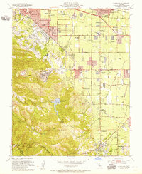
 1961 Cupertino1962 Print · USGSSanta Clara County is in the midst of its mid-century transformation from orchards to an urban hub during the early sixties. Genealogists and researchers can trace local landmarks like Loyola Corners, the sprawling Cement Plant, and historic schools from Fremont High Sch to Monta Vista.7 unique versions available
 - 1961 Map of San Jose West, 1962 Print
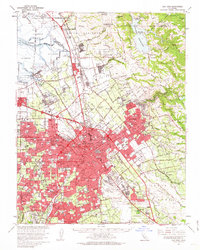
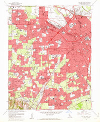 1961 San Jose West1962 Print · USGSThe Santa Clara Valley undergoes a massive mid-century transformation as the suburbs of San Jose and Campbell expand. Trace family roots at the Mission Santa Clara de Asis or locate mid-century landmarks like Willow Glen and Vasona Junction.6 unique versions available
 - 1961 Map of San Jose, 1963 Print
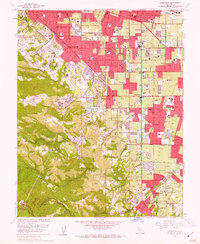
 1961 San Jose1963 Print · USGSThe Santa Clara Valley undergoes a massive post-war transformation in the early sixties as suburbs sprawl toward the bay. Genealogists and local historians can trace the development of SUNNYVALE, the grounds of Agnews State Hospital, and the rail corridors of the Southern Pacific.2 unique versions available
Showing maps 1-25 of 36
Frequently asked questions
- What are the different types of historical maps available for Birdland?
- What is the oldest map of Birdland?
- Where can I purchase historical maps of Birdland for my home or office?
- Where can I download high-res historical maps of Birdland?
- Are there historical topographic maps available for Birdland?
- Is there historical aerial imagery available for Birdland?
- Where are historical maps of Birdland sourced from?