1900s (20th Century) Maps of Beswick, California
Explore 9 historic maps of Beswick from the 1900s (20th Century). These maps offer a rare glimpse into what life looked like during the 1900s — showing old roads, neighborhoods, homes, and landmarks that have changed or disappeared over time.
Whether you're researching your family's past, planning a metal detecting trip, or studying how Beswick's landscape evolved across the 1900s, these high-resolution maps are a powerful tool for exploring the history of this region.
- Focus on a specific era: All maps on this page are from the 1900s, giving you a focused view of this time period.
- See what’s changed: Compare century-old streets, trails, and buildings to today's modern landscape using overlays and satellite layers.
- Research with precision: Use these maps for genealogy, historical research, land use analysis, or educational projects.
- View, download, or print: Maps are fully viewable online in high resolution, and can be downloaded or printed for your own records.
Start exploring Beswick's history through authentic maps from the 1900s. This is your window into the past.
Beswick, CA maps
(9)- 1934 Map of Macdoel
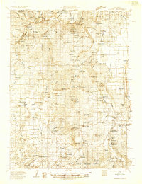 1934 Macdoel1934 Print · USGSSiskiyou County's high-desert valleys and timberlands come alive in this mid-thirties survey of the Klamath River corridor. Trace the early development of Macdoel and Snowden, or locate vanished landmarks like the Old Hoffman Mill and Smith Sawmill.
 - 1941 Map of Macdoel
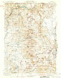 1941 Macdoel1941 Print · USGSUpper Siskiyou County is seen here just before the mid-century, where the timber industry and Southern Pacific rail lines defined the high valley landscape. Genealogists can trace early homesteads like Prather Ranch and Soule Ranch, alongside several local schoolhouses and the State Fish Hatchery.3 unique versions available
 - 1948 Map of Weed, 1950 Print
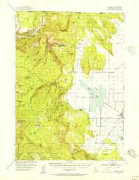
 1948 Weed1950 Print · USGSNorthern California and Southern Oregon are captured here during the post-war era, documenting the mountain-and-valley economies of the Klamath and Cascade ranges. Trace the legacy of local mining and timber at the King Solomon Mine, find old schools like Siskiyou County School, and follow the historic Southern Pacific RR route.2 unique versions available
 - 1950 Map of Weed
 1950 Weed1950 Print · USGSSiskiyou County and the surrounding Klamath mountains appear in the mid-century before extensive modern development. Genealogists and local historians can locate remote outposts like the Lee Brown Ranch and the specialized settlement of Darlingtonia.
 - 1954 Map of Macdoel, 1956 Print
 1954 Macdoel1956 Print · USGSSiskiyou County ranching and rail history converge in the mid-1950s as the Klamath River meets the Shasta Valley. Genealogists and historians can trace family land at the Meiss Ranch, locate the Oak Grove Sch (Aban'd), or follow the Southern Pacific tracks through Macdoel.3 unique versions available
 - 1958 Map of Weed, 1963 Print
 1958 Weed1963 Print · USGSThe Northern California high country of the late fifties is defined by the towering presence of Mt Shasta and the logging railroads of the Siskiyou range. Genealogists and researchers can trace remote mining sites like the China Mine and mountain settlements such as Sawyers Bar and Seiad Valley.3 unique versions available
 - 1963 Map of Weed
 1963 Weed1963 Print · USGSNorthern California during the early 1960s shows a landscape of steep mountain ranges and river-fed valleys at the height of the timber era. Researchers can trace the routes of the McCloud River RR, locate remote sites like the Holiday Mine, or find ancestral markers at the Scott Valley Cem.
 - 1979 Map of Yreka
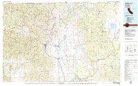 1979 Yreka1979 Print · USGSSiskiyou County in the late seventies is a rugged landscape of deep river canyons and high mountain valleys where logging and mining history meet. Genealogists and researchers can trace old rail stops and mining sites like Klamathon, Negro Boy Mine, and the settlement of Mugginsville.
 - 1985 Map of Secret Spring Mtn
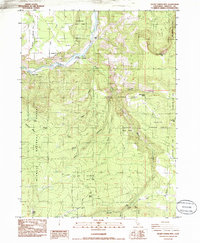 1985 Secret Spring Mtn1985 Print · USGSSiskiyou County's rugged Klamath River corridor is captured here in the mid-eighties, showing the isolated ranches and thermal springs of the region. Researchers can trace historic sites like Beswick, Klamath Hot Springs, and the Hessig Ranch.
End of results
Showing maps 1-9 of 9
Frequently asked questions
- What are the different types of historical maps available for Beswick?
- What is the oldest map of Beswick?
- Where can I purchase historical maps of Beswick for my home or office?
- Where can I download high-res historical maps of Beswick?
- Are there historical topographic maps available for Beswick?
- Is there historical aerial imagery available for Beswick?
- Where are historical maps of Beswick sourced from?