1950s Maps of Eagle Glen, Visalia
Explore 6 historic maps of Eagle Glen from the 1950s. These maps offer a rare glimpse into what life looked like during the 1950s — showing old roads, neighborhoods, homes, and landmarks that have changed or disappeared over time.
Whether you're researching your family's past, planning a metal detecting trip, or studying how Eagle Glen's landscape evolved across the 1950s, these high-resolution maps are a powerful tool for exploring the history of this region.
- Focus on a specific era: All maps on this page are from the 1950s, giving you a focused view of this time period.
- See what’s changed: Compare century-old streets, trails, and buildings to today's modern landscape using overlays and satellite layers.
- Research with precision: Use these maps for genealogy, historical research, land use analysis, or educational projects.
- View, download, or print: Maps are fully viewable online in high resolution, and can be downloaded or printed for your own records.
Start exploring Eagle Glen's history through authentic maps from the 1950s. This is your window into the past.
Eagle Glen, Visalia maps
(6)- 1950 Map of Visalia
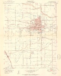 1950 Visalia1950 Print · USGSVisalia and the surrounding Tulare County farmland are shown here during a period of significant mid-century growth and agricultural development. Genealogists and local historians can trace the legacy of Tagus Ranch, locate dozens of local schools like Veva Blunt School, and follow the complex irrigation system of Mill Creek.2 unique versions available
 - 1950 Map of Exeter, 1952 Print
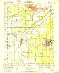 1950 Exeter1952 Print · USGSTulare County's agricultural heartland is documented here at a mid-century peak, showing the irrigation-driven growth of the San Joaquin Valley. Researchers can trace family history through local landmarks like Linnel PO, the Deep Creek Cem, and rural schools such as Outside Creek Sch.3 unique versions available
 - 1952 Map of Exeter, 1959 Print
 1952 Exeter1959 Print · USGSMid-century Tulare County is defined by its massive irrigation networks and citrus towns. Trace the rail-and-canal economy through Exeter and Woodlake, finding old sites like Linnel PO and the Sequoia State Fish Hatchery.2 unique versions available
 - 1955 Map of Fresno
 1955 Fresno1955 Print · USGSThe Central Valley and High Sierra meet in this mid-fifties study of California’s agricultural and wilderness heart. Researchers can trace the rail-side growth of Sanger, Selma, and Reedley or locate high-altitude landmarks like Mt Whitney and Hume Lake.
 - 1956 Map of Fresno
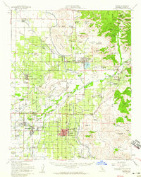
 1956 Fresno1956 Print · USGSThe Central Valley and High Sierra meet in this mid-fifties survey of a rapidly developing California interior. Researchers can trace the rail-and-water networks of Visalia, the footprint of Tulare Lake, and the remote heights of Sequoia National Park.
 - 1958 Map of Fresno
 1958 Fresno1958 Print · USGSThe Central Valley and High Sierra meet in this mid-century survey of the California heartland. Researchers can trace the rail-and-road network connecting Fresno and Visalia or locate high-country landmarks like Mt Whitney and Sequoia National Park.
End of results
Showing maps 1-6 of 6
Frequently asked questions
- What are the different types of historical maps available for Eagle Glen?
- What is the oldest map of Eagle Glen?
- Where can I purchase historical maps of Eagle Glen for my home or office?
- Where can I download high-res historical maps of Eagle Glen?
- Are there historical topographic maps available for Eagle Glen?
- Is there historical aerial imagery available for Eagle Glen?
- Where are historical maps of Eagle Glen sourced from?