Old Maps of Cow Creek, California
Explore 14 old maps of Cow Creek, spanning from 1896 to today. These high-resolution historic maps reveal how streets, neighborhoods, landmarks, and natural features evolved over time — perfect for genealogy, metal detecting, research, and local history exploration.
What you can do with these maps:
- See how Cow Creek changed over time: Compare historical maps to modern-day views to trace roads, homesites, rail lines & more.
- View detailed metadata: Each map includes creators, publishers, year, scale, and archive source.
- Overlay maps with satellite & LiDAR: Visualize the past alongside modern tools to explore terrain & human change.
- Trusted historical sources: Maps sourced from the USGS, Library of Congress, and other archives.
- Access maps your way: View online, download high-res files, or order prints for personal or research use.
Start exploring old maps of Cow Creek to uncover forgotten places, hidden landmarks, and the deep history beneath your feet.
Cow Creek, CA maps
(14)- 1896 Map of Dardanelles
 1896 Dardanelles1896 Print · USGSThe high Sierra wilderness in the late 1890s reveals a landscape of early forest reserves and remote outposts. Trace the early boundaries of Yosemite National Park and find historic stops like Baker Station and Brightman Flat.2 unique versions available
 - 1898 Map of Dardanelles
 1898 Dardanelles1898 Print · USGSThe high Sierra Nevada backcountry comes alive in the late 1890s, centered on the canyons of the Stanislaus and West Walker rivers. Trace early high-country travel routes through Sonora Pass or locate historical stops like Baker Station and the meadows of Brightman Flat.8 unique versions available
 - 1948 Map of Walker Lake
 1948 Walker Lake1948 Print · USGSThe high desert of Nevada and the eastern Sierra Nevada are captured just after the war as mining and ranching shaped the local economy. Genealogists can trace family connections to centers like Hawthorne and Mina or locate the historic Rockland Mines and Aurora.2 unique versions available
 - 1956 Map of Pinecrest, 1959 Print
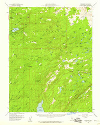 1956 Pinecrest1959 Print · USGSTuolumne County's High Sierra wilderness is captured here in the mid-fifties, just as mountain recreation and water infrastructure were expanding. Genealogists and hikers can trace the trails around Pinecrest, identify family-named sites like Gianelli Cabin, and locate historic meadows such as Leland Mdw.4 unique versions available
 - 1957 Map of Walker Lake
 1957 Walker Lake1957 Print · USGSThe Nevada-California borderlands in the mid-1950s show a rugged network of mining camps and river-valley towns centered around Walker Lake. Researchers can trace the Southern Pacific rail line and locate historical sites like Bodie, Sodaville, and the Leviathan Sulphur Mine.4 unique versions available
 - 1962 Map of Walker Lake
 1962 Walker Lake1962 Print · USGSThe high desert of western Nevada and the Sierra Nevada crest meet in this mid-century study of the Eastern Sierra frontier. Researchers can trace the Southern Pacific rail lines connecting Hawthorne to remote mining outposts like Bodie, Aurora, and Mina.
 - 1964 Map of Walker Lake
 1964 Walker Lake1964 Print · USGSThe high desert and the Sierra Nevada peaks come together in the mid-1960s, showing a landscape defined by mining, military installations, and vast wilderness. Genealogists and historians can trace the remnants of old mining camps at Bodie or Candelaria and follow the Southern Pacific rail lines.2 unique versions available
 - 1979 Map of Pinecrest, 1980 Print
 1979 Pinecrest1980 Print · USGSTuolumne County's high country is captured in the late seventies as recreational hubs and wilderness boundaries became more defined. Researchers can trace the development of Pinecrest and Strawberry, locate the Gianelli Cabin (Site), and find backcountry landmarks like Fiddlers Green and Coffin Hollow.3 unique versions available
 - 1985 Map of Bridgeport
 1985 Bridgeport1985 Print · USGSThe High Sierra and Nevada borderlands are captured in the mid-1980s, documenting a landscape of national forests and high-altitude mining districts. Researchers can trace historic operations like the Bodie Mine and May Lundy Mine or locate early settlements at Aurora and Baker Station.
 - 2001 Map of Pinecrest, 2004 Print
 2001 Pinecrest2004 Print · USGSTuolumne County's high Sierra recreation hubs are shown at the start of the new millennium as winter sports and summer camps thrived. Trace the development of Pinecrest and Strawberry or find remote landmarks like Dodge Ridge and Kenrick Horse Camp.
 - 2012 Map of Pinecrest, 2012 Print
 2012 Pinecrest2012 Print · USGSCovers Cow Creek, including Bumblebee, Tuolumne County, and other nearby areas
 - 2015 Map of Pinecrest, 2015 Print
 2015 Pinecrest2015 Print · USGSCovers Cow Creek, including Bumblebee, Tuolumne County, and other nearby areas
 - 2018 Map of Pinecrest, 2018 Print
 2018 Pinecrest2018 Print · USGSCovers Cow Creek, including Bumblebee, Tuolumne County, and other nearby areas
 - 2021 Map of Pinecrest, 2021 Print
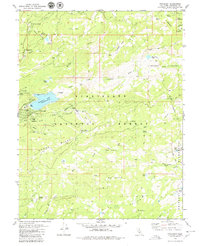
 2021 Pinecrest2021 Print · USGSTuolumne County's high-country terrain is captured here in the early twenty-first century, showing the established recreation and water systems of the Sierra Nevada. Trace the forest trails and seasonal meadows that define this landscape, from Leland Reservoir and Pinecrest Lake to the slopes of Dodge Ridge.
End of results
Showing maps 1-14 of 14
Top cities near Cow Creek
Frequently asked questions
- What are the different types of historical maps available for Cow Creek?
- What is the oldest map of Cow Creek?
- Where can I purchase historical maps of Cow Creek for my home or office?
- Where can I download high-res historical maps of Cow Creek?
- Are there historical topographic maps available for Cow Creek?
- Is there historical aerial imagery available for Cow Creek?
- Where are historical maps of Cow Creek sourced from?