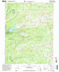
2001 Map of Pinecrest
USGS Topo · Published 2004About this map
Pinecrest and the surrounding high country of the Stanislaus National Forest are captured here during a period of established recreation and resource management. The landscape is defined by the sharp transition from the residential and resort clusters at Strawberry and Pinecrest Lake to the protected backcountry of the Emigrant Wilderness. The map documents a complex network of seasonal infrastructure, from the Dodge Ridge Ski Area and Pioneer Group Camp to the administrative and experimental boundaries of the Sheering Experimental Forest.
Find a feature on this map
57 named features on this map. Tap any name to fly to it.
Don’t see what you’re looking for? This feature index may not catch every label — zoom into the map to look around manually.
Map Details
Editions of this 2001 Pinecrest Map
This is the sole edition of this map. No revisions or reprints were ever made.
Other maps of this area

1891 · Big Trees
USGS Topo · 1:125,000

1894 · Big Trees
USGS Topo · 1:125,000

1896 · Dardanelles
USGS Topo · 1:125,000

1897 · Big Trees
USGS Topo · 1:125,000

1898 · Dardanelles
USGS Topo · 1:125,000

1901 · Big Trees
USGS Topo · 1:125,000

1947 · Sacramento
USGS Topo · 1:250,000

1948 · Walker Lake
USGS Topo · 1:250,000

1948 · Sacramento
USGS Topo · 1:250,000

1956 · Sacramento
USGS Topo · 1:250,000