
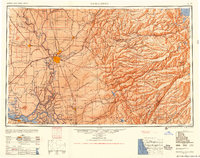
1956 Map of Sacramento
USGS Topo · Published 1956About this map
Sacramento serves as the focal point for this mid-century survey, anchoring a sprawling network of transportation and water infrastructure across the Central Valley and up into the Sierra Nevada. The map documents a significant era of post-war aviation and regional growth, highlighted by the strategic presence of McClellan AFB and Mather AFB. In the lowlands, the convergence of the Sacramento River, American River, and the Mokelumne River defines the agricultural and transit corridor, while the rail networks of the Southern Pacific RR and Sacramento Northern RR connect established valley towns like Woodland and Lodi. To the east, the terrain rises sharply through the Eldorado National Forest, revealing a high-altitude landscape of glacial lakes including Lake Tahoe, Fallen Leaf Lake, and the peaks of Desolation Valley. This transition from the flat delta of Suisun Bay to the granite summits of the Sierra captures the state's mid-century water management system through reservoirs like Pardee Reservoir and Salt Springs Reservoir.
Find a feature on this map
362 named features on this map. Tap any name to fly to it.
Don’t see what you’re looking for? This feature index may not catch every label — zoom into the map to look around manually.
Map Details
Editions of this 1956 Sacramento Map
2 editions found
Other maps of this area

1888 · Marysville
USGS Topo · 1:125,000

1888 · Smartsville
USGS Topo · 1:125,000

1889 · Jackson
USGS Topo · 1:125,000

1889 · Pyramid Peak
USGS Topo · 1:125,000

1889 · Markleeville
USGS Topo · 1:125,000

1891 · Sacramento
USGS Topo · 1:125,000

1891 · Carson
USGS Topo · 1:125,000

1891 · Markleeville
USGS Topo · 1:125,000

1891 · Colfax
USGS Topo · 1:125,000

1891 · Truckee
USGS Topo · 1:125,000