1891 Map of Sacramento
USGS Topo · Published 1891About this map
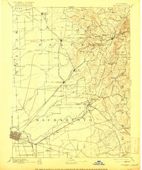
The American River system dominates this late 19th-century landscape, branching into the North Fork American River and South Fork American River near the settlement of Folsom. This survey captures the transition from gold-rush-era mining sites to an agricultural and transit-driven economy. Historic waypoints like 12 Mile House and 6 Mile House stand along the roads, while the Placerville & Sacramento Road serves as a primary artery for trade. The Southern Pacific Railroad cuts a diagonal path through the northern foothills, connecting early hubs like Roseville, Rocklin, and Newcastle. Notable landmarks such as Mormon Island and Rattlesnake Bridge mark the river crossings, providing essential geographic context for researchers of early Gold Country infrastructure and Placer County genealogy. To the north, features like Whitney Ranch and Hotaling illustrate the early ranching and quarrying operations that defined the region before suburban development.
Find a feature on this map
94 named features on this map. Tap any name to fly to it.
Don’t see what you’re looking for? This feature index may not catch every label — zoom into the map to look around manually.
Map Details
Editions of this 1891 Sacramento Map
This is the sole edition of this map. No revisions or reprints were ever made.
Historical Maps of Sacramento Through Time
8 maps found