1940s Maps of Groveland, California
Explore 4 historic maps of Groveland from the 1940s. These maps offer a rare glimpse into what life looked like during the 1940s — showing old roads, neighborhoods, homes, and landmarks that have changed or disappeared over time.
Whether you're researching your family's past, planning a metal detecting trip, or studying how Groveland's landscape evolved across the 1940s, these high-resolution maps are a powerful tool for exploring the history of this region.
- Focus on a specific era: All maps on this page are from the 1940s, giving you a focused view of this time period.
- See what’s changed: Compare century-old streets, trails, and buildings to today's modern landscape using overlays and satellite layers.
- Research with precision: Use these maps for genealogy, historical research, land use analysis, or educational projects.
- View, download, or print: Maps are fully viewable online in high resolution, and can be downloaded or printed for your own records.
Start exploring Groveland's history through authentic maps from the 1940s. This is your window into the past.
Groveland, CA maps
(4)- 1947 Map of San Jose, 1948 Print
 1947 San Jose1948 Print · USGSNorthern California's heartland is captured here just after the war, showing the rapid growth of the Santa Clara and Central Valleys. Researchers can trace the legacy of rail and water at Castle Air Force Base, Stockton, and the Hetch Hetchy Aqueduct.
 - 1947 Map of Groveland, 1964 Print
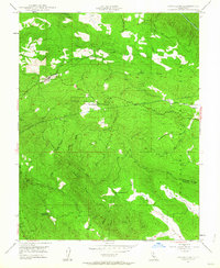 1947 Groveland1964 Print · USGSThe foothills of the Sierra Nevada are surveyed here in the late 1940s, documenting the legacy of the Gold Rush in Tuolumne County. Genealogists and historians can locate the Bret Harte Cabin, the old settlement at Second Garrotte, and rural landmarks like the Red Jacket Mine.4 unique versions available
 - 1948 Map of Tuolumne, 1953 Print
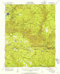 1948 Tuolumne1953 Print · USGSTuolumne County in the late 1940s reveals a rugged landscape of mining camps and early water infrastructure. Genealogists can trace family holdings like Murphy Ranch and Ralph Ranch alongside the historic Sierra RR and the Bret Harte Cabin.4 unique versions available
 - 1949 Map of Groveland
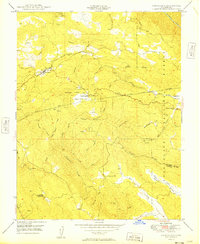 1949 Groveland1949 Print · USGSTuolumne County at the dawn of the 1950s reveals a landscape defined by gold-rush remnants and massive water projects. Genealogists and historians can trace the Bret Harte Cabin, identify the local Cem, and locate the Kanaka Mine along the Tuolumne River.
End of results
Showing maps 1-4 of 4
Top cities near Groveland
Frequently asked questions
- What are the different types of historical maps available for Groveland?
- What is the oldest map of Groveland?
- Where can I purchase historical maps of Groveland for my home or office?
- Where can I download high-res historical maps of Groveland?
- Are there historical topographic maps available for Groveland?
- Is there historical aerial imagery available for Groveland?
- Where are historical maps of Groveland sourced from?