1990s Maps of Tuolumne Meadows, California
Explore 2 historic maps of Tuolumne Meadows from the 1990s. These maps offer a rare glimpse into what life looked like during the 1990s — showing old roads, neighborhoods, homes, and landmarks that have changed or disappeared over time.
Whether you're researching your family's past, planning a metal detecting trip, or studying how Tuolumne Meadows's landscape evolved across the 1990s, these high-resolution maps are a powerful tool for exploring the history of this region.
- Focus on a specific era: All maps on this page are from the 1990s, giving you a focused view of this time period.
- See what’s changed: Compare century-old streets, trails, and buildings to today's modern landscape using overlays and satellite layers.
- Research with precision: Use these maps for genealogy, historical research, land use analysis, or educational projects.
- View, download, or print: Maps are fully viewable online in high resolution, and can be downloaded or printed for your own records.
Start exploring Tuolumne Meadows's history through authentic maps from the 1990s. This is your window into the past.
Tuolumne Meadows, CA maps
(2)- 1990 Map of Vogelsang Peak
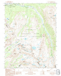
 1990 Vogelsang Peak1990 Print · USGSYosemite's high country is documented in the 1990s as it appeared before modern climate shifts impacted its alpine ice and remote camps. Backcountry researchers can trace the intersection of the John Muir Trail and the Pacific Crest National Scenic Trail near Vogelsang High Sierra Camp and the Maclure Glacier.
 - 1994 Map of Vogelsang Peak, 1995 Print
 1994 Vogelsang Peak1995 Print · USGSYosemite's high country is captured here during the mid-nineties, showing the intersection of legendary wilderness routes. Trace the convergence of the John Muir Trail and Pacific Crest Trail near the Vogelsang High Sierra Camp and the icy reach of the Maclure Glacier.2 unique versions available
End of results
Showing maps 1-2 of 2
Frequently asked questions
- What are the different types of historical maps available for Tuolumne Meadows?
- What is the oldest map of Tuolumne Meadows?
- Where can I purchase historical maps of Tuolumne Meadows for my home or office?
- Where can I download high-res historical maps of Tuolumne Meadows?
- Are there historical topographic maps available for Tuolumne Meadows?
- Is there historical aerial imagery available for Tuolumne Meadows?
- Where are historical maps of Tuolumne Meadows sourced from?