1940s Maps of Henderson, Colorado
Explore 2 historic maps of Henderson from the 1940s. These maps offer a rare glimpse into what life looked like during the 1940s — showing old roads, neighborhoods, homes, and landmarks that have changed or disappeared over time.
Whether you're researching your family's past, planning a metal detecting trip, or studying how Henderson's landscape evolved across the 1940s, these high-resolution maps are a powerful tool for exploring the history of this region.
- Focus on a specific era: All maps on this page are from the 1940s, giving you a focused view of this time period.
- See what’s changed: Compare century-old streets, trails, and buildings to today's modern landscape using overlays and satellite layers.
- Research with precision: Use these maps for genealogy, historical research, land use analysis, or educational projects.
- View, download, or print: Maps are fully viewable online in high resolution, and can be downloaded or printed for your own records.
Start exploring Henderson's history through authentic maps from the 1940s. This is your window into the past.
Henderson, CO maps
(2)- 1940 Map of Brighton
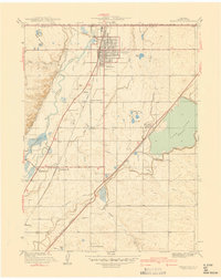 1940 Brighton1940 Print · USGSThe irrigated farmlands of Adams County come to life in this pre-war survey of the South Platte Valley. Genealogists and local historians can trace the footprint of the Denver Poor Farm and old rural schools like Pleasant Plains Sch or Cactus Ridge School.
 - 1944 Map of Brighton
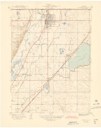 1944 Brighton1944 Print · USGSThe agricultural heart of the South Platte Valley is captured here during the mid-forties as irrigation and railroads transformed the plains. Genealogists and local historians can trace the foundations of Brighton and find vanished sites like the Denver Poor Farm or Pleasant Plains Sch.
End of results
Showing maps 1-2 of 2
Top cities near Henderson
- Denver historical maps
- Aurora historical maps
- Lakewood historical maps
- Thornton historical maps
- Arvada historical maps
- Westminster historical maps
See more
Frequently asked questions
- What are the different types of historical maps available for Henderson?
- What is the oldest map of Henderson?
- Where can I purchase historical maps of Henderson for my home or office?
- Where can I download high-res historical maps of Henderson?
- Are there historical topographic maps available for Henderson?
- Is there historical aerial imagery available for Henderson?
- Where are historical maps of Henderson sourced from?