Old Maps of Littleton, Colorado
Explore 35 old maps of Littleton, spanning from 1890 to today. These high-resolution historic maps reveal how streets, neighborhoods, landmarks, and natural features evolved over time — perfect for genealogy, metal detecting, research, and local history exploration.
What you can do with these maps:
- See how Littleton changed over time: Compare historical maps to modern-day views to trace roads, homesites, rail lines & more.
- View detailed metadata: Each map includes creators, publishers, year, scale, and archive source.
- Overlay maps with satellite & LiDAR: Visualize the past alongside modern tools to explore terrain & human change.
- Trusted historical sources: Maps sourced from the USGS, Library of Congress, and other archives.
- Access maps your way: View online, download high-res files, or order prints for personal or research use.
Start exploring old maps of Littleton to uncover forgotten places, hidden landmarks, and the deep history beneath your feet.
Littleton, CO maps
(35)- 1890 Map of East Denver
 1890 East Denver1890 Print · USGSDenver and the surrounding plains are captured in the late frontier era as a complex web of irrigation canals and iron rails. Researchers can trace early water systems like the High Line Ditch or locate early settlements such as Parker's and Scranton.
 - 1899 Map of West Denver
 1899 West Denver1899 Print · USGSThe Denver metropolitan area and its western foothills appear in the late Victorian era as a burgeoning rail and irrigation hub. Researchers can trace the early footprints of Denver, Golden, and Littleton, alongside industrial sites like the Louisville Coal Mine and the grounds of Fort Logan.
 - 1935 Map of East Denver Nos. 3 and 4
 1935 East Denver Nos. 3 and 41935 Print · USGSSoutheast Denver and the surrounding High Plains are captured here in the mid-1930s as residential growth began to push into Douglas County. Researchers can locate early landmarks like Fairmount Cemetery, the settlement of Sullivan, and the Melvin Sch.
 - 1941 Map of Fort Logan
 1941 Fort Logan1941 Print · USGSThe western edges of Denver and the community of Sheridan are captured here just before the mid-century population boom. Researchers can trace the layout of the Fort Logan Military Reservation and locate local landmarks like Loretto Heights College and Sloan Lake.
 - 1942 Map of Highland Ranch
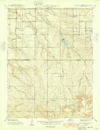
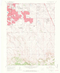
 1942 Highland Ranch1942 Print · USGSThe northern Douglas County ranchlands appear here in the early 1940s as a quiet expanse of large family estates and critical water canals. Researchers can trace the early boundaries of Highland Ranch, locate the Cheese Ranch, and find rural landmarks like Curtis Sch and the Englewood Dam.
 - 1942 Map of Littleton
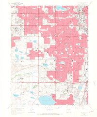
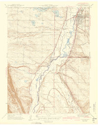 1942 Littleton1942 Print · USGSLittleton and the South Platte River valley appear here just before the mid-century boom, shaped by a vital network of railroads and reservoirs. Researchers can trace early rural life at Deer Creek Sch, the riverside siding at Struby, and the waters of Marston Lake.2 unique versions available
 - 1948 Map of Fort Logan
 1948 Fort Logan1948 Print · USGSSouthwest Denver and Jefferson County emerge as a hub of military, medical, and educational institutions in the years following the war. Genealogists and historians can locate specific sites like the Craig Colony sanatorium, Loretto Heights College, and the sprawling Fort Logan Military Reservation.
 - 1949 Map of Highland Ranch
 1949 Highland Ranch1949 Print · USGSArapahoe and Douglas counties were still defined by sprawling cattle operations and critical water infrastructure during the late 1940s. Genealogists and local historians can locate early landmarks like Cheese Ranch, Curtis Sch, and the original Highland Ranch headquarters.2 unique versions available
 - 1953 Map of Denver, 1964 Print
 1953 Denver1964 Print · USGSDenver and the Colorado Front Range are captured here during a decade of post-war growth and military expansion. Researchers can trace the sprawling rail lines of the Union Pacific, locate the State Capitol, and explore historic mountain mining hubs like Central City.6 unique versions available
 - 1957 Map of Denver
 1957 Denver1957 Print · USGSDenver and the Colorado Front Range are seen here during a mid-century period of intense military and urban expansion. Trace the footprints of the Rocky Mountain Arsenal, the early United States Air Force Academy, and the Lowry AF Base.
 - 1957 Map of Fort Logan, 1958 Print
 1957 Fort Logan1958 Print · USGSDenver's southwestern suburbs were in a period of significant postwar growth during the late fifties, blending military grounds with new residential tracts. Local historians can trace the footprints of the Fort Logan Military Reservation, the campus of Loretto Heights College, and the sprawling Federal Center.
 - 1957 Map of Highlands Ranch, 1958 Print
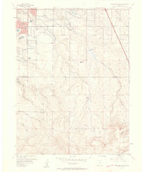 1957 Highlands Ranch1958 Print · USGSDouglas and Arapahoe counties are shown here in the late fifties as the area south of Denver began its suburban transition. Genealogists and local historians can trace the foundations of Greenwood Village, the footprint of Cheese Ranch, and the early site of Bar None Airport.2 unique versions available
 - 1957 Map of Littleton, 1958 Print
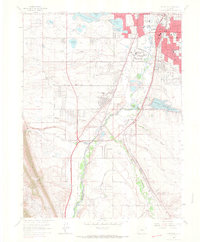
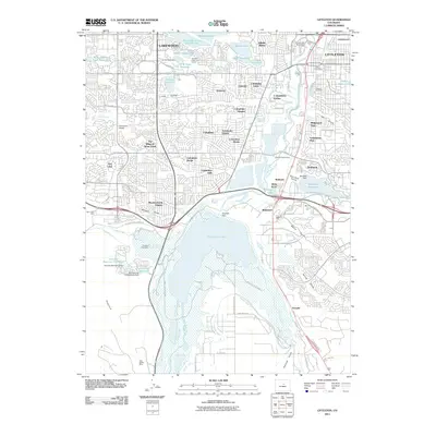
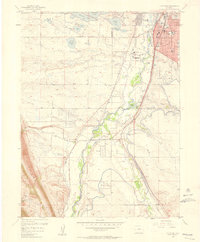 1957 Littleton1958 Print · USGSLittleton and the South Platte River valley are shown in the late fifties as suburban growth begins to overtake older ranch lands. Genealogists and local historians can trace the foundations of Littleton, find the Centennial Racetrack, and locate rural settlements like Acequia and Riverside.2 unique versions available
 - 1958 Map of Denver
 1958 Denver1958 Print · USGSDenver and the Colorado Front Range are captured here during the mid-century suburban boom. Trace the footprints of military installations like Buckley Air Force Base alongside the established rail networks of the Colorado & Southern Ry.
 - 1960 Map of Denver
 1960 Denver1960 Print · USGSDenver and the Colorado Front Range are seen here at a pivotal moment of postwar expansion into the plains and foothills. Researchers can trace the mid-century rail network of the Denver & Rio Grande Western RR and locate historic institutional landmarks like Buckley Field and the Colorado School of Mines.
 - 1965 Map of Fort Logan, 1967 Print
 1965 Fort Logan1967 Print · USGSMid-century Denver and its southwestern suburbs are seen here during a period of rapid growth. Researchers can trace institutional footprints like Fort Logan and the Federal Correctional Institute alongside old rail lines and Marston Lake.5 unique versions available
 - 1965 Map of Highlands Ranch, 1967 Print
 1965 Highlands Ranch1967 Print · USGSThe Highlands Ranch area is captured here during the mid-sixties as suburban neighborhoods began to push south from Denver. Researchers can trace the early footprint of Littleton and Greenwood Village alongside historic rural properties like McArthur Ranch and Cheesman Ranch.8 unique versions available
 - 1965 Map of Littleton, 1967 Print
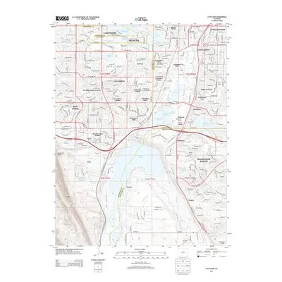
 1965 Littleton1967 Print · USGSSouth of Denver in the mid-1960s, this area shows the early suburban transformation of the South Platte valley. Trace the dual rail lines serving Blakeland or locate landmarks like Centennial Racetrack and Columbine Airpark.5 unique versions available
 - 1981 Map of Denver East
 1981 Denver East1981 Print · USGSEastern Colorado comes alive in the early eighties as the Front Range urban corridor pushes into the plains. Genealogists and historians can trace the growth of Aurora and Brighton alongside the historic Union Pacific line and the massive Rocky Mountain Arsenal.2 unique versions available
 - 1983 Map of Denver West
 1983 Denver West1983 Print · USGSThe Front Range and Denver's western suburbs meet in the early 1980s, documenting the era's growth from the mountain peaks to the valley floor. Genealogists and historians can trace the foundations of Lakewood and Golden, or locate high-altitude landmarks like the Moffat Tunnel and Mount Olivet Cem.2 unique versions available
 - 2010 Map of Highlands Ranch, 2010 Print
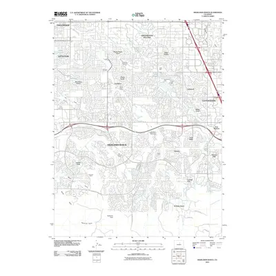 2010 Highlands Ranch2010 Print · USGSCovers Littleton, including Highlands Ranch, Centennial, and other nearby areas
 - 2011 Map of Littleton, 2011 Print
 2011 Littleton2011 Print · USGSCovers Littleton, including Lakewood, Englewood, and other nearby areas
 - 2011 Map of Fort Logan, 2011 Print
 2011 Fort Logan2011 Print · USGSCovers Littleton, including Lakewood, Englewood, and other nearby areas
 - 2013 Map of Littleton, 2013 Print
 2013 Littleton2013 Print · USGSCovers Littleton, including Lakewood, Englewood, and other nearby areas
 - 2013 Map of Fort Logan, 2013 Print
 2013 Fort Logan2013 Print · USGSCovers Littleton, including Lakewood, Englewood, and other nearby areas
Showing maps 1-25 of 35
Top cities near Littleton
- Denver historical maps
- Aurora historical maps
- Lakewood historical maps
- Arvada historical maps
- Highlands Ranch historical maps
- Centennial historical maps
See more
Top neighborhoods of Littleton
Frequently asked questions
- What are the different types of historical maps available for Littleton?
- What is the oldest map of Littleton?
- Where can I purchase historical maps of Littleton for my home or office?
- Where can I download high-res historical maps of Littleton?
- Are there historical topographic maps available for Littleton?
- Is there historical aerial imagery available for Littleton?
- Where are historical maps of Littleton sourced from?