
1890 Map of East Denver
USGS Topo · Published 1890About this map
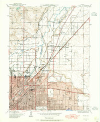
Denver stands as a burgeoning hub at the edge of the plains in this late nineteenth-century survey, its expanding street grid giving way to a landscape defined by irrigation and infrastructure. The vital role of water management in the arid region is clearly visible through the winding paths of the City Ditch, Burlington Ditch, and the extensive High Line Ditch, which redirect flow from the South Platte River to support new settlements and agriculture. Industry is anchored by the Grant Smelting Co. near Argo, reflecting the city's connection to the era's mining wealth.
Find a feature on this map
45 named features on this map. Tap any name to fly to it.
Don’t see what you’re looking for? This feature index may not catch every label — zoom into the map to look around manually.
Map Details
Editions of this 1890 East Denver Map
This is the sole edition of this map. No revisions or reprints were ever made.
Other maps of this area

1893 · Platte Canyon
USGS Topo · 1:125,000

1894 · Castle Rock
USGS Topo · 1:125,000

1899 · West Denver
USGS Topo · 1:125,000

1902 · Greeley
USGS Topo · 1:125,000

1904 · Niwot
USGS Topo · 1:62,500

1913 · Castle Rock
USGS Topo · 1:125,000

1935 · East Denver Nos. 3 and 4
USGS Topo · 1:48,000
1938 · Derby
USGS Topo · 1:24,000

1938 · Long Branch
USGS Topo · 1:24,000

1939 · Coal Creek
USGS Topo · 1:24,000