
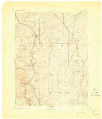
1894 Map of Castle Rock
USGS Topo · Published 1894About this map
Castle Rock stands as the central landmark of this late nineteenth-century reconnaissance, where the high plains meet the dramatic buttes of the Colorado Front Range. The landscape is defined by a sophisticated early transit corridor, with the Denver and Rio Grande Railroad and the Atchison Topeka and Santa Fe Railroad running parallel through the Plum Creek valley. This mapping captures the region's early water management infrastructure, most notably the Castlewood Dam on Cherry Creek, a critical and historically significant structure for irrigation in the arid divide country. To the south, the terrain rises toward Mt Herman and Palmer Lake, marking the transition into the higher elevations of El Paso County. Small agricultural and ranching hubs like Elizabeth, Franktown, and Elbert are connected by a web of creeks including Running Creek and Bijou Creek, illustrating the dispersed settlement patterns of the 1890s.
Find a feature on this map
36 named features on this map. Tap any name to fly to it.
Don’t see what you’re looking for? This feature index may not catch every label — zoom into the map to look around manually.
Map Details
Editions of this 1894 Castle Rock Map
2 editions found
Other maps of this area

1890 · East Denver
USGS Topo · 1:125,000

1893 · Big Springs
USGS Topo · 1:125,000

1893 · Platte Canyon
USGS Topo · 1:125,000

1893 · Colorado Springs
USGS Topo · 1:125,000

1894 · Pikes Peak
USGS Topo · 1:125,000

1899 · West Denver
USGS Topo · 1:125,000

1901 · Pikes Peak
USGS Topo · 1:125,000

1901 · Pikes Peak
USGS Topo · 1:62,500

1909 · Colorado Springs
USGS Topo · 1:125,000

1913 · Castle Rock
USGS Topo · 1:125,000