
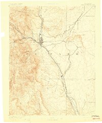
1893 Map of Colorado Springs
USGS Topo · Published 1896About this map
Colorado Springs serves as the central hub of a complex rail network in the late nineteenth century, where industrial coal towns like Franceville meet the early tourist gateways of the Front Range. The landscape is defined by the meeting of the high plains and the foothills, featuring the world-renowned Garden of the Gods and the steep ascent of the Manitou and Pikes Peak RR (Cog Wheel). Topographer Willard D. Johnson and geographer A.H. Thompson recorded a period of rapid expansion, documenting the routes of the Denver and Rio Grande Railroad and the Colorado Midland Railroad as they pushed through the canyons. Beyond the city, the map reveals local landmarks such as Burial Rocks and Corral Bluffs, alongside smaller settlements like Edgerton and Falcon that supported the region's ranching and mining interests.
Find a feature on this map
53 named features on this map. Tap any name to fly to it.
Don’t see what you’re looking for? This feature index may not catch every label — zoom into the map to look around manually.
Map Details
Editions of this 1893 Colorado Springs Map
2 editions found
Other maps of this area

1889 · Canon City
USGS Topo · 1:125,000

1891 · Pueblo
USGS Topo · 1:125,000

1891 · Nepesta
USGS Topo · 1:125,000

1892 · Canon City
USGS Topo · 1:125,000

1893 · Nepesta
USGS Topo · 1:125,000

1893 · Big Springs
USGS Topo · 1:125,000

1893 · Platte Canyon
USGS Topo · 1:125,000

1894 · Pikes Peak
USGS Topo · 1:125,000

1894 · Castle Rock
USGS Topo · 1:125,000

1894 · Pueblo
USGS Topo · 1:125,000