1899 Map of West Denver
USGS Topo · Published 1899About this map
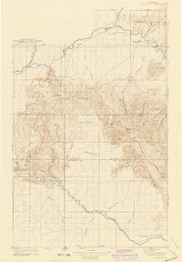
Denver and its western periphery at the close of the nineteenth century reveal a landscape where early agricultural irrigation and coal mining meet the expanding rail network of the Front Range. The prominent South Platte River and man-made waterways like the High Line Ditch and Northern Colorado Irrigation Canal show the critical infrastructure required for settlement in this semi-arid region. To the north, the Louisville Coal Mine and nearby Coal Park indicate the area's industrial roots, while the dramatic topography of North Table Mt. and South Table Mt. looms over the established streets of Golden. The map meticulously tracks several major rail lines, including the Colorado and Southern R. R. and the U. P. R. R., which linked early communities such as Littleton, Arvada, and the military post at Fort Logan to the growing urban center.
Find a feature on this map
66 named features on this map. Tap any name to fly to it.
Don’t see what you’re looking for? This feature index may not catch every label — zoom into the map to look around manually.
Map Details
Editions of this 1899 West Denver Map
This is the sole edition of this map. No revisions or reprints were ever made.