1940s Maps of Tollgate Crossing, Aurora
Explore 3 historic maps of Tollgate Crossing from the 1940s. These maps offer a rare glimpse into what life looked like during the 1940s — showing old roads, neighborhoods, homes, and landmarks that have changed or disappeared over time.
Whether you're researching your family's past, planning a metal detecting trip, or studying how Tollgate Crossing's landscape evolved across the 1940s, these high-resolution maps are a powerful tool for exploring the history of this region.
- Focus on a specific era: All maps on this page are from the 1940s, giving you a focused view of this time period.
- See what’s changed: Compare century-old streets, trails, and buildings to today's modern landscape using overlays and satellite layers.
- Research with precision: Use these maps for genealogy, historical research, land use analysis, or educational projects.
- View, download, or print: Maps are fully viewable online in high resolution, and can be downloaded or printed for your own records.
Start exploring Tollgate Crossing's history through authentic maps from the 1940s. This is your window into the past.
Tollgate Crossing, Aurora maps
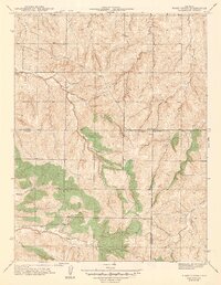
(3)- 1940 Map of Piney Creek
 1940 Piney Creek1940 Print · USGSThe High Plains of the late Depression era come to life here as the tri-county borders of Arapahoe, Douglas, and Elbert converge. Researchers can trace the rugged drainage patterns of Piney Creek, Sulphur Gulch, and Coal Creek before the landscape was altered by modern development.
 - 1942 Map of Piney Creek
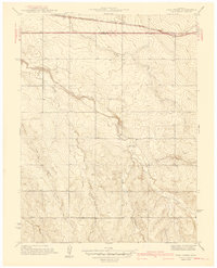
 1942 Piney Creek1942 Print · USGSThe Colorado high plains southeast of Denver appear as a quiet rural landscape in the early 1940s, just as modern infrastructure began to take shape. Genealogists and historians can trace the early drainage and road networks along Piney Creek, Sulphur Gulch, and Coal Creek.2 unique versions available
 - 1942 Map of Coal Creek
 1942 Coal Creek1942 Print · USGSThe Colorado high plains east of Denver show a landscape of intermittent streams and section-line roads in the late thirties. Genealogists and historians can locate the Coal Creek Sch and trace the path of the Union Pacific and Airline Road.
End of results
Showing maps 1-3 of 3
Frequently asked questions
- What are the different types of historical maps available for Tollgate Crossing?
- What is the oldest map of Tollgate Crossing?
- Where can I purchase historical maps of Tollgate Crossing for my home or office?
- Where can I download high-res historical maps of Tollgate Crossing?
- Are there historical topographic maps available for Tollgate Crossing?
- Is there historical aerial imagery available for Tollgate Crossing?
- Where are historical maps of Tollgate Crossing sourced from?