1970s Maps of Gilpin County, Colorado
Explore 4 historic maps of Gilpin County from the 1970s. These maps offer a rare glimpse into what life looked like during the 1970s — showing old roads, neighborhoods, homes, and landmarks that have changed or disappeared over time.
Whether you're researching your family's past, planning a metal detecting trip, or studying how Gilpin County's landscape evolved across the 1970s, these high-resolution maps are a powerful tool for exploring the history of this region.
- Focus on a specific era: All maps on this page are from the 1970s, giving you a focused view of this time period.
- See what’s changed: Compare century-old streets, trails, and buildings to today's modern landscape using overlays and satellite layers.
- Research with precision: Use these maps for genealogy, historical research, land use analysis, or educational projects.
- View, download, or print: Maps are fully viewable online in high resolution, and can be downloaded or printed for your own records.
Start exploring Gilpin County's history through authentic maps from the 1970s. This is your window into the past.
Gilpin County, CO maps
(4)- 1972 Map of Black Hawk, 1975 Print
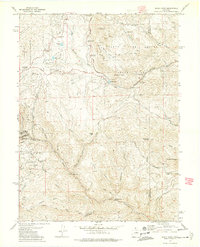 1972 Black Hawk1975 Print · USGSThe Colorado Front Range comes into focus in the early 1970s, revealing a landscape where historic mining claims meet newly established state parks. Researchers can trace local history through prominent sites like the Baltimore Mine, the Clear Creek Dredge Tailings, and Golden Gate Canyon State Park.5 unique versions available
 - 1972 Map of Central City, 1975 Print
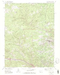 1972 Central City1975 Print · USGSThe Colorado mining districts of the early seventies are captured in high detail across the Gilpin and Clear Creek county lines. Researchers can trace the legacy of the gold rush through the Russell Gulch Cemetery, the streets of Nevadaville, and the dense mine workings on Seaton Mtn.2 unique versions available
 - 1972 Map of Tungsten, 1975 Print
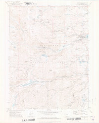
 1972 Tungsten1975 Print · USGSBoulder County in the early seventies reveals a landscape of high-altitude water works and deep-rooted mining operations. Researchers can trace the narrow-gauge heritage of the Denver Rio Grande and Western near old sites like Rollinsville, Pinecliffe, and the Ruby Mine.2 unique versions available
 - 1972 Map of Nederland, 1976 Print
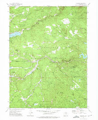
 1972 Nederland1976 Print · USGSIn the early 1970s, the mountain towns of Boulder and Gilpin Counties balanced their silver mining past with new recreational growth. Trace old railroad grades along the Denver and Rio Grande Western or locate historic diggings like the Caribou mines and Early Bird Mine.3 unique versions available
End of results
Showing maps 1-4 of 4
Top cities of Gilpin County
Frequently asked questions
- What are the different types of historical maps available for Gilpin County?
- What is the oldest map of Gilpin County?
- Where can I purchase historical maps of Gilpin County for my home or office?
- Where can I download high-res historical maps of Gilpin County?
- Are there historical topographic maps available for Gilpin County?
- Is there historical aerial imagery available for Gilpin County?
- Where are historical maps of Gilpin County sourced from?