1910s Maps of North Edenvale, Colorado
Explore 2 historic maps of North Edenvale from the 1910s. These maps offer a rare glimpse into what life looked like during the 1910s — showing old roads, neighborhoods, homes, and landmarks that have changed or disappeared over time.
Whether you're researching your family's past, planning a metal detecting trip, or studying how North Edenvale's landscape evolved across the 1910s, these high-resolution maps are a powerful tool for exploring the history of this region.
- Focus on a specific era: All maps on this page are from the 1910s, giving you a focused view of this time period.
- See what’s changed: Compare century-old streets, trails, and buildings to today's modern landscape using overlays and satellite layers.
- Research with precision: Use these maps for genealogy, historical research, land use analysis, or educational projects.
- View, download, or print: Maps are fully viewable online in high resolution, and can be downloaded or printed for your own records.
Start exploring North Edenvale's history through authentic maps from the 1910s. This is your window into the past.
North Edenvale, CO maps
(2)- 1914 Map of Creede
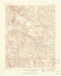 1914 Creede1914 Print · USGSMineral County mining camps and silver-era infrastructure are preserved in this pre-war survey. Genealogists and historians can trace industrial landmarks like the Nelson Tunnel alongside early settlements including Bachelor, Sunnyside, and Spar City.3 unique versions available
 - 1916 Map of Creede
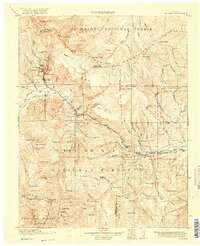 1916 Creede1916 Print · USGSThe silver boom of the San Juan Mountains is in full swing on this 1910s survey of the upper Rio Grande. Researchers can trace mining claims and tunnels at Bachelor, locate the Emma Mine, or find the old Pfeiffer School near Granger.3 unique versions available
End of results
Showing maps 1-2 of 2
Top cities near North Edenvale
Frequently asked questions
- What are the different types of historical maps available for North Edenvale?
- What is the oldest map of North Edenvale?
- Where can I purchase historical maps of North Edenvale for my home or office?
- Where can I download high-res historical maps of North Edenvale?
- Are there historical topographic maps available for North Edenvale?
- Is there historical aerial imagery available for North Edenvale?
- Where are historical maps of North Edenvale sourced from?