1980s Maps of Sunnyside, Colorado
Explore 2 historic maps of Sunnyside from the 1980s. These maps offer a rare glimpse into what life looked like during the 1980s — showing old roads, neighborhoods, homes, and landmarks that have changed or disappeared over time.
Whether you're researching your family's past, planning a metal detecting trip, or studying how Sunnyside's landscape evolved across the 1980s, these high-resolution maps are a powerful tool for exploring the history of this region.
- Focus on a specific era: All maps on this page are from the 1980s, giving you a focused view of this time period.
- See what’s changed: Compare century-old streets, trails, and buildings to today's modern landscape using overlays and satellite layers.
- Research with precision: Use these maps for genealogy, historical research, land use analysis, or educational projects.
- View, download, or print: Maps are fully viewable online in high resolution, and can be downloaded or printed for your own records.
Start exploring Sunnyside's history through authentic maps from the 1980s. This is your window into the past.
Sunnyside, CO maps
(2)- 1982 Map of Del Norte, 1983 Print
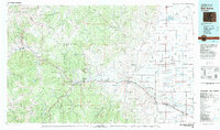 1982 Del Norte1983 Print · USGSThe Rio Grande Valley and San Juan Mountains are seen here in the early eighties, transitioning from rugged alpine peaks to the irrigated San Luis Valley plains. Researchers can trace the Denver and Rio Grande Western rail line and locate old regional hubs like Creede, Monte Vista, and Wagon Wheel Gap.
 - 1986 Map of Creede
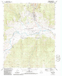 1986 Creede1986 Print · USGSMineral County silver mining history and Rio Grande rail corridors are frozen in time in this mid-eighties survey. Genealogists and historians can trace the Commodore Tunnel, the Sunnyside townsite, and the Denver and Rio Grande Western rail lines.
End of results
Showing maps 1-2 of 2
Top cities near Sunnyside
Frequently asked questions
- What are the different types of historical maps available for Sunnyside?
- What is the oldest map of Sunnyside?
- Where can I purchase historical maps of Sunnyside for my home or office?
- Where can I download high-res historical maps of Sunnyside?
- Are there historical topographic maps available for Sunnyside?
- Is there historical aerial imagery available for Sunnyside?
- Where are historical maps of Sunnyside sourced from?