1970s Maps of Grover Hill, Bridgeport
Explore 1 historic maps of Grover Hill from the 1970s. These maps offer a rare glimpse into what life looked like during the 1970s — showing old roads, neighborhoods, homes, and landmarks that have changed or disappeared over time.
Whether you're researching your family's past, planning a metal detecting trip, or studying how Grover Hill's landscape evolved across the 1970s, these high-resolution maps are a powerful tool for exploring the history of this region.
- Focus on a specific era: All maps on this page are from the 1970s, giving you a focused view of this time period.
- See what’s changed: Compare century-old streets, trails, and buildings to today's modern landscape using overlays and satellite layers.
- Research with precision: Use these maps for genealogy, historical research, land use analysis, or educational projects.
- View, download, or print: Maps are fully viewable online in high resolution, and can be downloaded or printed for your own records.
Start exploring Grover Hill's history through authentic maps from the 1970s. This is your window into the past.
Grover Hill, Bridgeport maps
(1)- 1970 Map of Bridgeport, 1972 Print
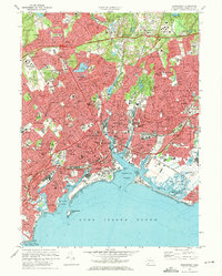 1970 Bridgeport1972 Print · USGSCoastal Connecticut thrived during the post-war era as industrial hubs expanded into modern suburban corridors. Genealogists and historians can trace neighborhood growth through dozens of sites like Mount Grove Cemetery, Sacred Heart University, and the Bridgeport Municipal Airport.4 unique versions available
End of results
Showing maps 1-1 of 1
Top cities near Grover Hill
- Brookhaven historical maps
- Oyster Bay historical maps
- Huntington historical maps
- Bridgeport historical maps
- Smithtown historical maps
- Norwalk historical maps
See more
Frequently asked questions
- What are the different types of historical maps available for Grover Hill?
- What is the oldest map of Grover Hill?
- Where can I purchase historical maps of Grover Hill for my home or office?
- Where can I download high-res historical maps of Grover Hill?
- Are there historical topographic maps available for Grover Hill?
- Is there historical aerial imagery available for Grover Hill?
- Where are historical maps of Grover Hill sourced from?