1950s Maps of Cheshire, Connecticut
Explore 4 historic maps of Cheshire from the 1950s. These maps offer a rare glimpse into what life looked like during the 1950s — showing old roads, neighborhoods, homes, and landmarks that have changed or disappeared over time.
Whether you're researching your family's past, planning a metal detecting trip, or studying how Cheshire's landscape evolved across the 1950s, these high-resolution maps are a powerful tool for exploring the history of this region.
- Focus on a specific era: All maps on this page are from the 1950s, giving you a focused view of this time period.
- See what’s changed: Compare century-old streets, trails, and buildings to today's modern landscape using overlays and satellite layers.
- Research with precision: Use these maps for genealogy, historical research, land use analysis, or educational projects.
- View, download, or print: Maps are fully viewable online in high resolution, and can be downloaded or printed for your own records.
Start exploring Cheshire's history through authentic maps from the 1950s. This is your window into the past.
Cheshire, CT maps
(4)- 1954 Map of Mount Carmel, 1956 Print
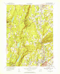 1954 Mount Carmel1956 Print · USGSHamden and Cheshire are shown here in the mid-fifties, just as the Wilbur Cross Parkway was shaping modern travel through these valleys. Trace family roots at Hillside Cemetery or explore the rail era along the New York New Haven and Hartford Railroad.3 unique versions available
 - 1954 Map of Wallingford, 1956 Print
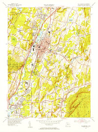 1954 Wallingford1956 Print · USGSThe Quinnipiac River valley in the mid-1950s shows the bustling center of Wallingford alongside its growing suburban neighborhoods. Trace local family roots at St Johns Cem or locate historic landmarks like the Gaylord Farms Sanatorium and Lyman Hall High Sch.3 unique versions available
 - 1955 Map of Meriden, 1956 Print
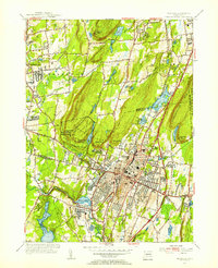 1955 Meriden1956 Print · USGSMid-century Meriden and Southington are shown here during a period of significant post-war development and infrastructure growth. Genealogists can trace family landmarks at Bishops Corner and Stillmans Corner, or locate ancestors at Walnut Grove Cem.3 unique versions available
 - 1955 Map of Southington, 1956 Print
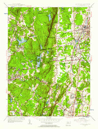 1955 Southington1956 Print · USGSThe industrial corridor between Southington and Cheshire is captured here in the mid-fifties, showing a landscape defined by water reservoirs and rail lines. Genealogists can trace family sites at Northeast Burying Ground or locate landmarks like the State Reformatory and Chase Country Club.2 unique versions available
End of results
Showing maps 1-4 of 4
Top cities near Cheshire
- Hartford historical maps
- New Haven historical maps
- Waterbury historical maps
- New Britain historical maps
- West Hartford historical maps
- Meriden historical maps
See more
Top neighborhoods of Cheshire
- Mountaincrest historical maps
- Brooksvale historical maps
- Ives Corner historical maps
- West Cheshire historical maps
- Fox Hollow historical maps
- Fox Hollow historical maps
See more
Frequently asked questions
- What are the different types of historical maps available for Cheshire?
- What is the oldest map of Cheshire?
- Where can I purchase historical maps of Cheshire for my home or office?
- Where can I download high-res historical maps of Cheshire?
- Are there historical topographic maps available for Cheshire?
- Is there historical aerial imagery available for Cheshire?
- Where are historical maps of Cheshire sourced from?