1950s Maps of Bakerville, New Hartford
Explore 2 historic maps of Bakerville from the 1950s. These maps offer a rare glimpse into what life looked like during the 1950s — showing old roads, neighborhoods, homes, and landmarks that have changed or disappeared over time.
Whether you're researching your family's past, planning a metal detecting trip, or studying how Bakerville's landscape evolved across the 1950s, these high-resolution maps are a powerful tool for exploring the history of this region.
- Focus on a specific era: All maps on this page are from the 1950s, giving you a focused view of this time period.
- See what’s changed: Compare century-old streets, trails, and buildings to today's modern landscape using overlays and satellite layers.
- Research with precision: Use these maps for genealogy, historical research, land use analysis, or educational projects.
- View, download, or print: Maps are fully viewable online in high resolution, and can be downloaded or printed for your own records.
Start exploring Bakerville's history through authentic maps from the 1950s. This is your window into the past.
Bakerville, New Hartford maps
(2)- 1951 Map of Torrington
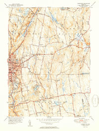 1951 Torrington1951 Print · USGSTorrington and Harwinton appear at a mid-century peak of industrial activity and rural transition. Genealogists can trace family names at Hillside Cemetery, locate the old Harwinton Sch, or find local landmarks like Turtle Rock.2 unique versions available
 - 1956 Map of Torrington, 1958 Print
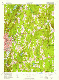 1956 Torrington1958 Print · USGSTorrington and Harwinton appear here in the mid-fifties, showing a landscape defined by industrial river corridors and expanding residential hills. Genealogists can locate family sites at Hillside Cemetery, Sons of Jacob Cem, or the old Wolcott Sch.5 unique versions available
End of results
Showing maps 1-2 of 2
Top cities near Bakerville
- Waterbury historical maps
- New Britain historical maps
- Bristol historical maps
- Southington historical maps
- Torrington historical maps
- Farmington historical maps
See more
Frequently asked questions
- What are the different types of historical maps available for Bakerville?
- What is the oldest map of Bakerville?
- Where can I purchase historical maps of Bakerville for my home or office?
- Where can I download high-res historical maps of Bakerville?
- Are there historical topographic maps available for Bakerville?
- Is there historical aerial imagery available for Bakerville?
- Where are historical maps of Bakerville sourced from?