1950s Maps of Lebanon, Connecticut
Explore 4 historic maps of Lebanon from the 1950s. These maps offer a rare glimpse into what life looked like during the 1950s — showing old roads, neighborhoods, homes, and landmarks that have changed or disappeared over time.
Whether you're researching your family's past, planning a metal detecting trip, or studying how Lebanon's landscape evolved across the 1950s, these high-resolution maps are a powerful tool for exploring the history of this region.
- Focus on a specific era: All maps on this page are from the 1950s, giving you a focused view of this time period.
- See what’s changed: Compare century-old streets, trails, and buildings to today's modern landscape using overlays and satellite layers.
- Research with precision: Use these maps for genealogy, historical research, land use analysis, or educational projects.
- View, download, or print: Maps are fully viewable online in high resolution, and can be downloaded or printed for your own records.
Start exploring Lebanon's history through authentic maps from the 1950s. This is your window into the past.
Lebanon, CT maps
(4)- 1953 Map of Colchester, 1954 Print
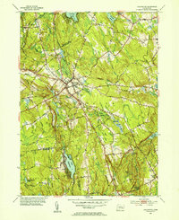 1953 Colchester1954 Print · USGSColchester and its surrounding hamlets are captured in the early 1950s, revealing a landscape of historic crossroads and family-named corners. Genealogists can trace ancestral locations at St Johns Cem, Exeter Ch, and rural intersections like Avery Corner.7 unique versions available
 - 1953 Map of Willimantic, 1954 Print
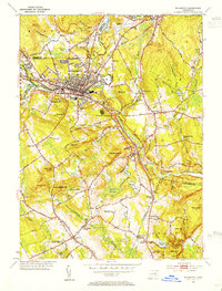 1953 Willimantic1954 Print · USGSWillimantic and its surrounding hill country are captured here in the early fifties, showing a bustling rail junction at the height of its mid-century character. Trace the routes of the Central Vermont Railway, find the historic Trumbull Cem, or locate the old Willimantic State Teachers College.5 unique versions available
 - 1953 Map of Fitchville, 1955 Print
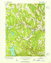 1953 Fitchville1955 Print · USGSNew London County in the early fifties maintains a landscape of river-driven industry and lakeside recreation. Researchers can trace historic turnpikes, the Central Vermont rail line, and family landmarks like Avery Corner and Scott Hill Cem.5 unique versions available
 - 1953 Map of Columbia, 1955 Print
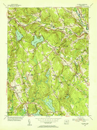 1953 Columbia1955 Print · USGSTolland County and its surrounding highlands appear here in the mid-1950s, a period when rural schoolhouses and family cemeteries still anchored the community. Genealogists can locate family landmarks like Utley Hill Cem, Porter Sch, and the rail stops along the New York and New Haven and Hartford Railroad.6 unique versions available
End of results
Showing maps 1-4 of 4
Top cities near Lebanon
- Manchester historical maps
- Norwich historical maps
- Glastonbury historical maps
- Vernon historical maps
- Mansfield historical maps
- Windham historical maps
See more
Top neighborhoods of Lebanon
- Exeter historical maps
- Williams Crossing historical maps
- Avery Corner historical maps
- Village Hill historical maps
- Liberty Hill historical maps
- Lebanon Green Historic District historical maps
Frequently asked questions
- What are the different types of historical maps available for Lebanon?
- What is the oldest map of Lebanon?
- Where can I purchase historical maps of Lebanon for my home or office?
- Where can I download high-res historical maps of Lebanon?
- Are there historical topographic maps available for Lebanon?
- Is there historical aerial imagery available for Lebanon?
- Where are historical maps of Lebanon sourced from?