1930s Maps of District of Columbia
Explore 3 historic maps of District of Columbia from the 1930s. These maps offer a rare glimpse into what life looked like during the 1930s — showing old roads, neighborhoods, homes, and landmarks that have changed or disappeared over time.
Whether you're researching your family's past, planning a metal detecting trip, or studying how District of Columbia's landscape evolved across the 1930s, these high-resolution maps are a powerful tool for exploring the history of this region.
- Focus on a specific era: All maps on this page are from the 1930s, giving you a focused view of this time period.
- See what’s changed: Compare century-old streets, trails, and buildings to today's modern landscape using overlays and satellite layers.
- Research with precision: Use these maps for genealogy, historical research, land use analysis, or educational projects.
- View, download, or print: Maps are fully viewable online in high resolution, and can be downloaded or printed for your own records.
Start exploring District of Columbia's history through authentic maps from the 1930s. This is your window into the past.
District of Columbia maps
(3)- 1934 Map of Upper Marlboro (east half)
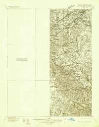 1934 Upper Marlboro (east half)1934 Print · USGSPrince George's County is captured here in the mid-1930s as a rural landscape of crossroads communities and evolving rail lines. Genealogists and historians can trace family roots through landmarks like St Luke Ch, Glenarden Sch, and the route of the Chesapeake Beach RR.2 unique versions available
 - 1937 Map of Upper Marlboro
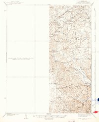 1937 Upper Marlboro1937 Print · USGSMid-century Prince George’s County is captured here just as modern highways began to intersect its rural rail and school districts. Researchers can find old landmarks like St Barnabas Ch, the Collington Sch, and the busy Pennsylvania railroad line.
 - 1938 Map of Upper Marlboro
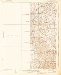 1938 Upper Marlboro1938 Print · USGSPrince George's County at the dawn of the modern era is captured here, showing the rural landscape before the post-war expansion. Researchers can trace family sites near Holy Trinity Ch, follow the Pennsylvania RR line, and locate centers like Rosaryville and Glenn Dale.3 unique versions available
End of results
Showing maps 1-3 of 3
Top cities of District of Columbia
Frequently asked questions
- What are the different types of historical maps available for District of Columbia?
- What is the oldest map of District of Columbia?
- Where can I purchase historical maps of District of Columbia for my home or office?
- Where can I download high-res historical maps of District of Columbia?
- Are there historical topographic maps available for District of Columbia?
- Is there historical aerial imagery available for District of Columbia?
- Where are historical maps of District of Columbia sourced from?