1980s Maps of Downtown Melbourne, Melbourne
Explore 1 historic maps of Downtown Melbourne from the 1980s. These maps offer a rare glimpse into what life looked like during the 1980s — showing old roads, neighborhoods, homes, and landmarks that have changed or disappeared over time.
Whether you're researching your family's past, planning a metal detecting trip, or studying how Downtown Melbourne's landscape evolved across the 1980s, these high-resolution maps are a powerful tool for exploring the history of this region.
- Focus on a specific era: All maps on this page are from the 1980s, giving you a focused view of this time period.
- See what’s changed: Compare century-old streets, trails, and buildings to today's modern landscape using overlays and satellite layers.
- Research with precision: Use these maps for genealogy, historical research, land use analysis, or educational projects.
- View, download, or print: Maps are fully viewable online in high resolution, and can be downloaded or printed for your own records.
Start exploring Downtown Melbourne's history through authentic maps from the 1980s. This is your window into the past.
Downtown Melbourne, Melbourne maps
(1)- 1981 Map of Cape Canaveral, 1983 Print
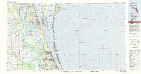 1981 Cape Canaveral1983 Print · USGSThe Space Coast and the Florida marshlands meet in the early eighties as aerospace technology and nature preserves sit side-by-side. Trace the development of Cocoa Beach, the sprawling grounds of the Kennedy Space Center, and the inland waters of Lake Poinsett.
End of results
Showing maps 1-1 of 1
Frequently asked questions
- What are the different types of historical maps available for Downtown Melbourne?
- What is the oldest map of Downtown Melbourne?
- Where can I purchase historical maps of Downtown Melbourne for my home or office?
- Where can I download high-res historical maps of Downtown Melbourne?
- Are there historical topographic maps available for Downtown Melbourne?
- Is there historical aerial imagery available for Downtown Melbourne?
- Where are historical maps of Downtown Melbourne sourced from?