1960s Maps of The Landlings, Fort Lauderdale
Explore 1 historic maps of The Landlings from the 1960s. These maps offer a rare glimpse into what life looked like during the 1960s — showing old roads, neighborhoods, homes, and landmarks that have changed or disappeared over time.
Whether you're researching your family's past, planning a metal detecting trip, or studying how The Landlings's landscape evolved across the 1960s, these high-resolution maps are a powerful tool for exploring the history of this region.
- Focus on a specific era: All maps on this page are from the 1960s, giving you a focused view of this time period.
- See what’s changed: Compare century-old streets, trails, and buildings to today's modern landscape using overlays and satellite layers.
- Research with precision: Use these maps for genealogy, historical research, land use analysis, or educational projects.
- View, download, or print: Maps are fully viewable online in high resolution, and can be downloaded or printed for your own records.
Start exploring The Landlings's history through authentic maps from the 1960s. This is your window into the past.
The Landlings, Fort Lauderdale maps
(1)- 1962 Map of Pompano Beach, 1964 Print
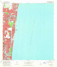 1962 Pompano Beach1964 Print · USGSThe Broward County shoreline was rapidly transforming in the early sixties as new canal-front neighborhoods expanded along the coast. Trace the development of Garden Isles and Sea Ranch Lakes, or locate mid-century landmarks like the Drive-in Theater and Holy Cross Hospital.5 unique versions available
End of results
Showing maps 1-1 of 1
Frequently asked questions
- What are the different types of historical maps available for The Landlings?
- What is the oldest map of The Landlings?
- Where can I purchase historical maps of The Landlings for my home or office?
- Where can I download high-res historical maps of The Landlings?
- Are there historical topographic maps available for The Landlings?
- Is there historical aerial imagery available for The Landlings?
- Where are historical maps of The Landlings sourced from?