Old Maps of Lauderhill, Broward County for Genealogy
Trace your family roots with 14 historic maps of Lauderhill. These high-res maps reveal old neighborhoods, homesites, landmarks, and streets — helping you uncover where your ancestors lived and how the area evolved over time.
- Explore historic neighborhoods: Identify where your relatives may have lived in the 1800s or 1900s.
- Compare maps over time: Trace the changes in streets, buildings, and landmarks for multi-generational research.
- Perfect for genealogy & ancestry research: Used by family historians and researchers to map out lineage and migration.
These maps are an incredible resource for exploring your personal connection to Lauderhill's past.
Lauderhill, Broward County maps
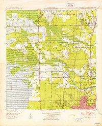
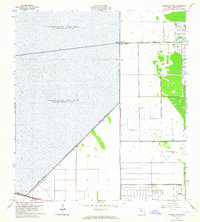
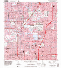
(14)- 1945 Map of Fort Lauderdale North
 1945 Fort Lauderdale North1945 Print · USGSCovers Lauderhill, including Fort Lauderdale, Pompano Beach, and other nearby areas
 - 1949 Map of Fort Lauderdale North
 1949 Fort Lauderdale North1949 Print · USGSCovers Lauderhill, including Fort Lauderdale, Pompano Beach, and other nearby areas2 unique versions available
 - 1949 Map of Fort Lauderdale South
 1949 Fort Lauderdale South1949 Print · USGSCovers Lauderhill, including Fort Lauderdale, Hollywood, and other nearby areas2 unique versions available
 - 1956 Map of West Palm Beach, 1964 Print
 1956 West Palm Beach1964 Print · USGSCovers Lauderhill, including Fort Lauderdale, Cape Coral, and other nearby areas2 unique versions available
 - 1957 Map of West Palm Beach
 1957 West Palm Beach1957 Print · USGSCovers Lauderhill, including Fort Lauderdale, Cape Coral, and other nearby areas
 - 1958 Map of West Palm Beach
 1958 West Palm Beach1958 Print · USGSCovers Lauderhill, including Fort Lauderdale, Cape Coral, and other nearby areas2 unique versions available
 - 1962 Map of Fort Lauderdale North, 1964 Print
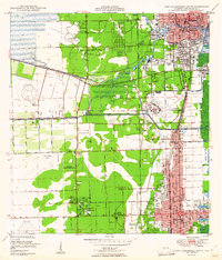
 1962 Fort Lauderdale North1964 Print · USGSCovers Lauderhill, including Fort Lauderdale, Pompano Beach, and other nearby areas4 unique versions available
 - 1962 Map of Fort Lauderdale South, 1964 Print
 1962 Fort Lauderdale South1964 Print · USGSCovers Lauderhill, including Fort Lauderdale, Hollywood, and other nearby areas3 unique versions available
 - 1963 Map of Cooper City NE, 1964 Print
 1963 Cooper City NE1964 Print · USGSCovers Lauderhill, including Sunrise, Plantation Acres, and other nearby areas4 unique versions available
 - 1981 Map of Fort Lauderdale, 1983 Print
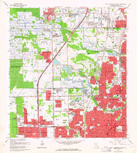
 1981 Fort Lauderdale1983 Print · USGSCovers Lauderhill, including Fort Lauderdale, Pembroke Pines, and other nearby areas
 - 1985 Map of Fort Lauderdale, 1986 Print
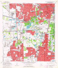
 1985 Fort Lauderdale1986 Print · USGSCovers Lauderhill, including Fort Lauderdale, Pembroke Pines, and other nearby areas2 unique versions available
 - 1987 Map of West Palm Beach, 1988 Print
 1987 West Palm Beach1988 Print · USGSCovers Lauderhill, including Fort Lauderdale, Cape Coral, and other nearby areas2 unique versions available
 - 1994 Map of Fort Lauderdale South, 1999 Print
 1994 Fort Lauderdale South1999 Print · USGSCovers Lauderhill, including Fort Lauderdale, Hollywood, and other nearby areas
 - 1995 Map of Fort Lauderdale North, 1999 Print
 1995 Fort Lauderdale North1999 Print · USGSCovers Lauderhill, including Fort Lauderdale, Pompano Beach, and other nearby areas
End of results
Showing maps 1-14 of 14
Frequently asked questions
- What are the different types of historical maps available for Lauderhill?
- What is the oldest map of Lauderhill?
- Where can I purchase historical maps of Lauderhill for my home or office?
- Where can I download high-res historical maps of Lauderhill?
- Are there historical topographic maps available for Lauderhill?
- Is there historical aerial imagery available for Lauderhill?
- Where are historical maps of Lauderhill sourced from?