Old Maps of Naples, Florida
Explore 19 old maps of Naples, spanning from 1956 to today. These high-resolution historic maps reveal how streets, neighborhoods, landmarks, and natural features evolved over time — perfect for genealogy, metal detecting, research, and local history exploration.
What you can do with these maps:
- See how Naples changed over time: Compare historical maps to modern-day views to trace roads, homesites, rail lines & more.
- View detailed metadata: Each map includes creators, publishers, year, scale, and archive source.
- Overlay maps with satellite & LiDAR: Visualize the past alongside modern tools to explore terrain & human change.
- Trusted historical sources: Maps sourced from the USGS, Library of Congress, and other archives.
- Access maps your way: View online, download high-res files, or order prints for personal or research use.
Start exploring old maps of Naples to uncover forgotten places, hidden landmarks, and the deep history beneath your feet.
Naples, FL maps
(19)- 1956 Map of West Palm Beach, 1964 Print
 1956 West Palm Beach1964 Print · USGSSouth Florida during the mid-fifties exhibits a fascinating balance between expanding coastal cities and the vast interior wetlands. Researchers can trace the development of inland settlements like Immokalee and Okeelanta or locate vanished landmarks like Chosen and Buckingham Cem.2 unique versions available
 - 1957 Map of West Palm Beach
 1957 West Palm Beach1957 Print · USGSSouthern Florida in the mid-fifties reveals a landscape defined by massive drainage canals and the early expansion of the Gold Coast. Genealogists and historians can trace industrial outposts like the Sugar plant and Everglades Labor Center, or locate the Jupiter Auxiliary Air Force Base.
 - 1958 Map of West Palm Beach
 1958 West Palm Beach1958 Print · USGSSouth Florida in the late fifties was a land of transition between massive agricultural works and rapid coastal growth. Genealogists and historians can trace old canal networks, early rail lines like the Florida East Coast, and landmarks like the Moore Haven Lock or Jupiter Auxiliary Air Force Base.2 unique versions available
 - 1958 Map of Naples South, 1959 Print
 1958 Naples South1959 Print · USGSCoastal Florida in the late fifties shows the early expansion of Naples and its waterfront canal systems. Trace the original shoreline and tidal passes from Gordon Pass south to the undeveloped reaches of Rookery Bay and Little Marco Pass.5 unique versions available
 - 1958 Map of Naples North, 1959 Print
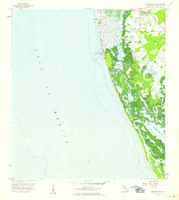
 1958 Naples North1959 Print · USGSCoastal Florida in the late fifties shows a landscape of burgeoning development and pristine waterways. Genealogists and historians can trace the footprint of early schools like Carver Sch, the Naples Airport, and the winding Gordon River before modern expansion.6 unique versions available
 - 1985 Map of Naples, 1986 Print
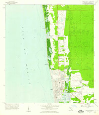
 1985 Naples1986 Print · USGSCoastal Florida in the mid-eighties shows a striking contrast between the growing beachfront of Naples and the preserved wilderness of the interior. Trace the development of Golden Gate or locate historical boundaries within the Seminole Indian Reservation and Corkscrew Swamp Sanctuary.2 unique versions available
 - 1987 Map of West Palm Beach, 1988 Print
 1987 West Palm Beach1988 Print · USGSSouth Florida is captured in the mid-1980s, showcasing the intricate balance between rapid coastal growth and the vast interior wetlands. Researchers can trace the drainage canals of The Everglades or locate the boundaries of the Big Cypress Seminole Indian Reservation and Loxahatchee National Wildlife Refuge.2 unique versions available
 - 2012 Map of Naples North, 2012 Print
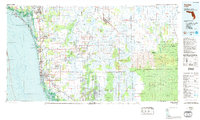
 2012 Naples North2012 Print · USGSCovers Naples, including Pelican Bay, North Naples, and other nearby areas
 - 2012 Map of Naples South, 2012 Print
 2012 Naples South2012 Print · USGSCovers Naples, including Collier County, United States, and other nearby areas
 - 2015 Map of Naples South, 2015 Print
 2015 Naples South2015 Print · USGSCovers Naples, including Collier County, United States, and other nearby areas
 - 2015 Map of Naples North, 2015 Print
 2015 Naples North2015 Print · USGSCovers Naples, including Pelican Bay, North Naples, and other nearby areas
 - 2018 Map of Naples North, 2018 Print
 2018 Naples North2018 Print · USGSCovers Naples, including Pelican Bay, North Naples, and other nearby areas
 - 2018 Map of Naples South, 2018 Print
 2018 Naples South2018 Print · USGSCovers Naples, including Collier County, United States, and other nearby areas
 - 2021 Map of Naples North, 2021 Print
 2021 Naples North2021 Print · USGSCovers Naples, including Pelican Bay, North Naples, and other nearby areas
 - 2021 Map of Naples South, 2021 Print
 2021 Naples South2021 Print · USGSCovers Naples, including Collier County, United States, and other nearby areas
 - 2024 Map of Naples South, 2024 Print
 2024 Naples South2024 Print · USGSCovers Naples, including Collier County, United States, and other nearby areas
 - 2024 Map of Naples North, 2024 Print
 2024 Naples North2024 Print · USGSCovers Naples, including Pelican Bay, North Naples, and other nearby areas
 - 2025 Map of Naples South, 2025 Print
 2025 Naples South2025 Print · USGSThe Florida Gulf Coast near Naples reveals its intricate balance of high-end residential canals and protected wilderness in the mid-2020s. Genealogists and local historians can locate the Trinity By The Cove Episcopal Church Cem or trace the transition from Naples to the secluded reaches of Keewaydin Island and Rookery Bay.
 - 2025 Map of Naples North, 2025 Print
 2025 Naples North2025 Print · USGSThe Florida coast near Naples shows its modern residential and maritime development at the end of the first quarter-century. Trace the layout of the coastal lagoons and civic hubs from the Naples Municipal Airport to the Collier County Courthouse.
End of results
Showing maps 1-19 of 19
Top cities near Naples
- Bonita Springs historical maps
- Marco Island historical maps
- Lely Resort historical maps
- Pelican Bay historical maps
- Naples Manor historical maps
- Lely historical maps
See more
Top neighborhoods of Naples
- Port Royal historical maps
- Sun Terrace historical maps
- Old Naples historical maps
- Park Shore historical maps
- Aqualane Shores historical maps
- Royal Harbor historical maps
See more
Frequently asked questions
- What are the different types of historical maps available for Naples?
- What is the oldest map of Naples?
- Where can I purchase historical maps of Naples for my home or office?
- Where can I download high-res historical maps of Naples?
- Are there historical topographic maps available for Naples?
- Is there historical aerial imagery available for Naples?
- Where are historical maps of Naples sourced from?