1990s Maps of Ortega Hills, Jacksonville
Explore 2 historic maps of Ortega Hills from the 1990s. These maps offer a rare glimpse into what life looked like during the 1990s — showing old roads, neighborhoods, homes, and landmarks that have changed or disappeared over time.
Whether you're researching your family's past, planning a metal detecting trip, or studying how Ortega Hills's landscape evolved across the 1990s, these high-resolution maps are a powerful tool for exploring the history of this region.
- Focus on a specific era: All maps on this page are from the 1990s, giving you a focused view of this time period.
- See what’s changed: Compare century-old streets, trails, and buildings to today's modern landscape using overlays and satellite layers.
- Research with precision: Use these maps for genealogy, historical research, land use analysis, or educational projects.
- View, download, or print: Maps are fully viewable online in high resolution, and can be downloaded or printed for your own records.
Start exploring Ortega Hills's history through authentic maps from the 1990s. This is your window into the past.
Ortega Hills, Jacksonville maps
(2)- 1993 Map of Orange Park
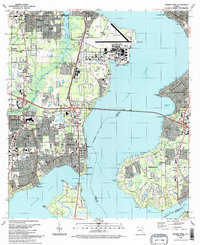 1993 Orange Park1993 Print · USGSThe riverfront communities of Clay and Duval counties were seeing significant suburban maturation in the early nineties. Genealogists and local historians can trace the development of Orange Park and Mandarin, locating landmarks like Magnolia Cem and the Jacksonville Naval Air Station.2 unique versions available
 - 1994 Map of Orange Park, 2002 Print
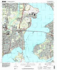 1994 Orange Park2002 Print · USGSThe riverfront communities of Orange Park and Mandarin are shown in the 1990s as they expanded around the St Johns River. Researchers can trace old family sites at Magnolia Cem and Mandarin Cem or locate the sprawling Jacksonville Naval Air Station.
End of results
Showing maps 1-2 of 2
Frequently asked questions
- What are the different types of historical maps available for Ortega Hills?
- What is the oldest map of Ortega Hills?
- Where can I purchase historical maps of Ortega Hills for my home or office?
- Where can I download high-res historical maps of Ortega Hills?
- Are there historical topographic maps available for Ortega Hills?
- Is there historical aerial imagery available for Ortega Hills?
- Where are historical maps of Ortega Hills sourced from?