1990s Maps of Park Avenue, Jacksonville
Explore 2 historic maps of Park Avenue from the 1990s. These maps offer a rare glimpse into what life looked like during the 1990s — showing old roads, neighborhoods, homes, and landmarks that have changed or disappeared over time.
Whether you're researching your family's past, planning a metal detecting trip, or studying how Park Avenue's landscape evolved across the 1990s, these high-resolution maps are a powerful tool for exploring the history of this region.
- Focus on a specific era: All maps on this page are from the 1990s, giving you a focused view of this time period.
- See what’s changed: Compare century-old streets, trails, and buildings to today's modern landscape using overlays and satellite layers.
- Research with precision: Use these maps for genealogy, historical research, land use analysis, or educational projects.
- View, download, or print: Maps are fully viewable online in high resolution, and can be downloaded or printed for your own records.
Start exploring Park Avenue's history through authentic maps from the 1990s. This is your window into the past.
Park Avenue, Jacksonville maps
(2)- 1993 Map of Bayard
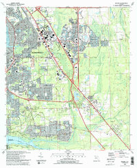 1993 Bayard1993 Print · USGSSoutheast Jacksonville in the early nineties shows a landscape of rapid suburban growth between the St Johns River and Julington Creek. Researchers can trace the development of Mandarin, locate the Julington Cem, and follow the historical path of the Florida East Coast RR.2 unique versions available
 - 1994 Map of Bayard, 2003 Print
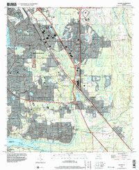 1994 Bayard2003 Print · USGSSouthern Duval County was undergoing rapid transformation in the mid-nineties as Jacksonville expanded toward the St. Johns River. Genealogists and local historians can trace established communities like Mandarin and Loretto alongside landmarks like Julington Cem and New Allen Chapel.
End of results
Showing maps 1-2 of 2
Frequently asked questions
- What are the different types of historical maps available for Park Avenue?
- What is the oldest map of Park Avenue?
- Where can I purchase historical maps of Park Avenue for my home or office?
- Where can I download high-res historical maps of Park Avenue?
- Are there historical topographic maps available for Park Avenue?
- Is there historical aerial imagery available for Park Avenue?
- Where are historical maps of Park Avenue sourced from?